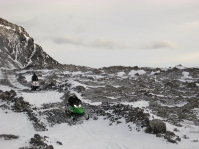
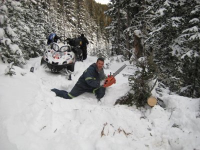
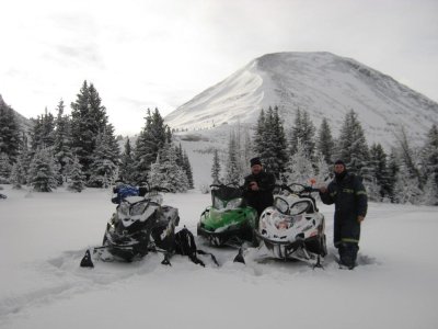
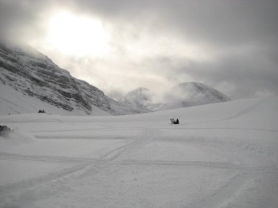
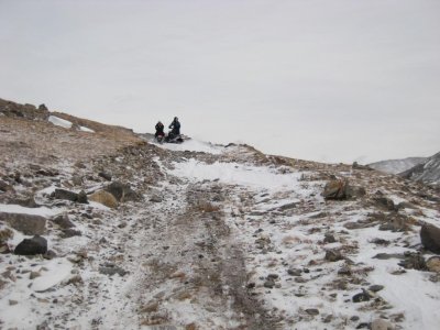
couple more pics from the trip on Dec 12/13 with foothillsm8 and calgarysledguy.... first tracks over the pass for 2013/2014 season. I added a couple of the trail on the way over.... this is as good as it gets all year folks!

You are using an out of date browser. It may not display this or other websites correctly.
You should upgrade or use an alternative browser.
You should upgrade or use an alternative browser.
Cataract/Etherington 2013/14 Thread
- Thread starter Kaz Dog
- Start date

- Thread starter
- #143
Great snow all along the "west" side of the trail system.
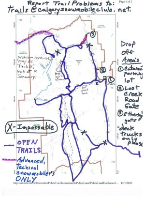
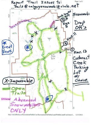
Here is the last map for 2013, as the ESRD Flood Coordinator was out with myself and another club member to inspect and GPS trails we had not covered to date. There is some more work to do in January to remove large trees across Upper Raspberry Pass Trail to make the trail more enjoyable, and groomer ready (we may have an opportunity to test out some grooming equipment later this winter).
Here is the last map for 2013, as the ESRD Flood Coordinator was out with myself and another club member to inspect and GPS trails we had not covered to date. There is some more work to do in January to remove large trees across Upper Raspberry Pass Trail to make the trail more enjoyable, and groomer ready (we may have an opportunity to test out some grooming equipment later this winter).
Attachments
- Thread starter
- #144
Trail Report for Thursday, December 19
(Changes made from the last report will be in this colour)
MUCH MORE SIGNAGE IS REQUIRED FOR ALL TRAILS, AS WELL AS CURRENT SIGNAGE MUST BE MADE MORE VISIBLE.
Etherington Provincial Recreation Area (P.R.A.) (“the parking lot” - usual drop off area, now outside the gate)
- Main gate just off the Forestry Truck Road (Hwy 940/F.T.R.) is closed due to un-repairable road damage that occurred during the flood
- Users are allowed to park on the access road to the gate, PLEASE DO NOT PARK TRAILERS HERE, NOT MUCH ROOM, AND NO TURNAROUND!- fence boards have been removed to the left of the gate to allow for snowmobile travel from unloaded truck deck, down through ditch, and back onto road on the other side - ONLY! NO QUADS, Side-by-sides, trucks, or motorcycles allowed. NO WHEELED VEHICLE ALLOWED.
- travel through the P.R.A. as close as possible to the road/parking lot/trail entrance - NO FREERIDING THROUGH THE AREA or the access road will be blocked off at the F.T.R.!- no current access south onto the Valley Bottom Trail on the historical trail through the campground
- a plan is being worked on to provide an approved temporary trail to access the Valley Bottom Trail – yet to be completed.
- a sign is to be installed for public information purposes, as soon as approval and production can be completed - DONE
"Lost Creek Road gate" drop-off/turnaround
- Please be conscientious how you park here as it is not a large area
- park close to the edges of the area/grader blading, and leave the middle to "fill-in"
- leave enough room to access the drop-off for one vehicle with trailer to pass all the way through and back on the F.T.R.
- Do not use the Lost Creek Roadto access the Cataract Creek valley, this is only for the trapper in the valley.
-immediately upon disembarking from the parking area, get on the Valley Bottom Trail to the south, as it has been repaired
Cataract Creek P.R.A. Campground and day-use area/parking lot
- A ramp was constructed behind the day shelter on Wednesday, December 11, for snowmobile use. Please use this ramp to access Cataract Creek Trail.
- This is to be used as the main drop-off area for snowmobiling for this winter. We are hopeful that the Etherington P.R.A. parking lot will be available next winter.
THE TRAILS (listed from North to South)
Etherington Creek Trail:
- The trail from the Etherington parking lot to the junction of Etherington, Raspberry Pass and Baril Loop trails is okay, with the trail going through some washouts and “narrowing” - TRAVEL WITH CARE!
- The portion of the trail from the above mentioned junction to the point where Baril Loop trail rejoins starts out okay (500 yards?) but has an impassable obstruction on the trail. First, a portion of the creek has been re-directed cutting the trail off, and then a large washout with large trees and debris is just beyond. THIS SECTION OF THE TRAIL IS TO REMAIN CLOSED THIS WINTER, AND RE-ROUTED VIA BARIL LOOP TRAIL. This section may be permanently closed.
Baril Loop Trail:
- This trail is in very good shape, relatively speaking. Please use it instead of Etherington Trail at the junction mentioned above, to advance further on the trail system. There is currently a turnaround at the “end” of the loop, where it rejoins Etherington Trail, as there is much damage on the trail at this point.
Baril Creek Trail:
- have information that it is passable - NO NEW OR NOVICE SNOWMOBILERS!!! This trail looks to start easy, but is for very seasoned/expert/double black diamond snowmobilers only!
Raspberry Pass Trial:
- Passable from Etherington Trail to Cataract Creek Trail as of Dec. 1, 2013
- New, temporary trail must be fully flagged yet, but maintenance participants discovered a temporary trail that avoids the heavily damaged trail at the north end.
Upper Raspberry Pass Trail:
- Open and passable, a few large trees remain to be removed to widen the trail.
Loggers' Trail:
- no information available
Valley Bottom Trail:- a temporary trail has been constructed around/uphill of the washout at the south end, just before the connection to the Cataract Creek Trail
- "caution" tape and surveyor's tape has been placed across the trail to direct people around the washout to the temporary trail - and flagged.
- has major damage with a 35 foot washout at the north end, just before the Etherington Campground Trail
- this may require substantial reconstruction with heavy equipment and possibly a bridge, if not a complete re-route
Cataract Creek Trail:
- This trail is now accessible from the Cataract Creek P.R.A. day use area/parking lot.
- All Bridges accessing the "south" trails from the Cataract creek valley off of this trail are washed out, but there are two crossing points over the frozen creek, currently
- there is one bridge left at the very west end of the trail which allows one to reach the Cataract Loop Trail
- There are three washouts west of the Valley Bottom Trail that are still passable on the Cataract Creek Trail
- A fourth washout, near the turnoff north to Raspberry Pass Trail/south to Cummings Creek Trail has a temporary trail down and through a shallow washout and up beside the existing trail
- this temporary trail will be used until the washout - 15 feet wide - has a bridge built over it this next year (hopefully)
Cataract Loop Trail:
- the "straight" portion of this trail has not been travelled, but expectations are that, from clearing done last year, the trail will be mostly open and in good condition
Wilkinson Summit Trail:
- currently the only trail leading out of Cataract Creek day use parking lot, and ride-able after the snow we have just had
- BEWARE OF THE TWO "DIPS" IN THE ROAD, THEY ARE NOW BETTER SIGNED by Albert Transport, but be conscious of them while on this trail
- when you leave the trail (that is the Forestry Truck Road) and try and access Pasque Trail, at the south end of the CCSA traversing eastßà west, the bridges over Wilkinson Creek (100 foot span now) and one further on across a tributary (30 foot span) are both "out"/destroyed, currently no access to Pasque Trail here.
- the access gate across the trail just off of the F.T.R. has been closed with a twig from a tree, but should be signed as a closed trail and locked
Cummings Creek Trail:
- is in very good shape through to where the crossover trail is to Skyline, Oyster Excursion, and Fallers Trails
- about half way down the trail further, south of the crossover trail, there is a washout that is impassible - DO NOT ENTER, FRUSTRATION WILL ENSUE! You may access this part of Cummings Creek Trail from Pasque Trail but only proceed half way north toward the "crossover" trail, where the major, impassable washout has occurred.
Fallers Trail:
- We began checking this trail from the south end. It is in good condition, but requires signage. This is my way of saying we got lost / turned around and did not get all the way through.
Skyline Trail:
- This trail is open and cleared
Oyster Excursion Trail:
- This trail is open and cleared
- A large washout in the northern section was able to be gotten through and the trail has had to be re-routed as most of the old trail is washed away. Be careful and go slowly while going through this washout
Pasque Trial:
- as mentioned previously, the two bridges that access this trail off of Wilkinson Summit Trail are out, with one being completely un-crossable
- You may access this trail from Skyline or Oyster Excursion Trail, and go as far east as the washed out bridge near Wilkinson Summit Trail
- you may access Cummings Creek Trail, at its’ southern most point, from Pasque Trail, but only proceed half way along toward the "crossover" trail, where the major, impassable washout has occurred.
Organizer
Cataract Creek Snowmobile Area Trails Committee
Calgary Snowmobile Club
Last edited:
BRP QSC
Active VIP Member
That last pic is the normal but I have seen 3feet of snow on there in the morning and by afternoon the winds pick up and looks just like that again. rough area for sure but worth the trip almost every time. Thanks for the pics
Rich
Rich
neddacsac
Active VIP Member
Went over the pass today. Conditions were good in the trees with waist deep snow in some places. There is a crust about 8" down in the open areas. The bottom has started to turn to sugar already. Trail up is the usual rough ride with crossings in fair shape. Could use another dump of snow as its mostly tracked out now.
Anyone know if cataract got any of this snow?
anyone headed out tomorrow?
Nakiska is a pretty good reference, and they received about 15cm.... I'm headed out tomorrow, but certainly not there! Way better snow to be found other places!!
neddacsac
Active VIP Member
Conditions should be good tomorrow. Nakiska reported 15cm last night and radar has been showing snow most of the day. Be careful if anyone goes over the pass. Avy conditions are ugly.South Rockies : Latest Bulletins : Bulletins : Canadian Avalanche Centre : avalanche.ca
You guys(kazdog) have done a great job stabilizing the area after such wide spread devastation......
Just to clarify things a bit as far as parking...is there any scope for 2wd vehicle and small trailer to stage/park and also to turn around on the road...if I understand correctly..one has to venture as far as the lost creek road....is parking just on the west side ?
I just dont want to get in a pickle...
- Thread starter
- #154
I have been recommending that all trucks that do not have sleds on a sled deck only on them, park at either the Lost Creek Road gate area (Kms. 11) or Cataract Creek parking lot (Kms. 13) instead of just off Hwy 940 at the Etherington PRA road to the locked gate (Kms. 5 - from Highwood House). My reasoning has been that to turn around a trailer on the road is not possible, and to back one out may be problematic if a number of trucks with decks get parked on the road. As a matter of fact, over the Christmas Holidays, I had to pull a one-ton truck and trailer "around" with my half-ton 4x4 who had jack-knifed himself and gotten stuck trying to turn around.
What I have noticed for people with a trailer and parking on the Etherington PRA road is they pull ahead of the road and back in, mostly, if they can. Safest is to go further to one of the other parking areas, as trail access is much better too. But if your plan is to go over Fording Pass, try and back in on the Etherington PRA road that leads to the locked gate.
What I have noticed for people with a trailer and parking on the Etherington PRA road is they pull ahead of the road and back in, mostly, if they can. Safest is to go further to one of the other parking areas, as trail access is much better too. But if your plan is to go over Fording Pass, try and back in on the Etherington PRA road that leads to the locked gate.
You guys(kazdog) have done a great job stabilizing the area after such wide spread devastation......
Just to clarify things a bit as far as parking...is there any scope for 2wd vehicle and small trailer to stage/park and also to turn around on the road...if I understand correctly..one has to venture as far as the lost creek road....is parking just on the west side ?
I just dont want to get in a pickle...
Last edited:
- Thread starter
- #156
Trail Report for Sunday, December 29
(Changes made from the last report will be in this colour)
Etherington Provincial Recreation Area (P.R.A.) (“the parking lot” - usual drop off area, now outside the gate)
- Main gate just off the Forestry Truck Road (Hwy 940/F.T.R.) is closed due to un-repairable road damage that occurred during the flood
- Users are allowed to park on the access road to the gate, PLEASE DO NOT PARK TRAILERS HERE, NOT MUCH ROOM, AND NO TURNAROUND!
- fence boards have been removed to the left of the gate to allow for snowmobile travel from unloaded truck deck, down through ditch, and back onto road on the other side - ONLY! NO QUADS, Side-by-sides, trucks, or motorcycles allowed. NO WHEELED VEHICLE ALLOWED.
- travel through the P.R.A. as close as possible to the road/parking lot/trail entrance - NO FREERIDING THROUGH THE AREA or the access road will be blocked off at the F.T.R.!- no current access south onto the Valley Bottom Trail on the historical trail through the campground
- a temporary trail to access the Valley Bottom Trail from here is not possible this winter, please do not drive along Hwy 940, or through the campground, looking for access
- a sign on a post beside the open fence access is installed for public information purposes, and a larger one is in the works
"Lost Creek Road gate" drop-off/turnaround
- Please be conscientious how you park here as it is not a large area
- park close to the edges of the area/grader plowing, and leave the middle to "fill-in"
- leave enough room to access the drop-off for one vehicle with trailer to pass all the way through and back on the F.T.R.
- Do not use the Lost Creek Road to access the Cataract Creek valley, this is only for the trapper in the valley.
-immediately upon disembarking from the parking area, get on the Valley Bottom Trail to the south, as it has been repaired
Cataract Creek P.R.A. Campground and day-use area/parking lot- A ramp was constructed behind the day shelter on Wednesday, December 11, for snowmobile use. Please use this ramp to access Cataract Creek Trail.
- This is to be used as the main drop-off area for snowmobiling for this winter. We are hopeful that the Etherington P.R.A. parking lot will be available next winter.
THE TRAILS (listed from North to South)
Etherington Creek Trail:
- The trail from the Etherington parking lot to the junction of Etherington, Raspberry Pass and Baril Loop trails is okay, with the trail going through some washouts and “narrowing” - TRAVEL WITH CARE!
- The trail from this point west at about the 500 yard mark is blocked and not repairable this winter. First, a portion of the creek has been re-directed cutting the trail off, and then a large washout with large trees and debris is just beyond. This section may be permanently closed in the future. To best enjoy the Etherington Creek Trail is to proceed to the end of the Cataract Creek Trail and snowmobile to the north. You can go a very long way, passing by a great lookout/viewing area but will eventually have to turn around at a very major washout at Loggers Trail.
Baril Loop Trail:
- This trail is in very good shape, relatively speaking. Please use it instead of Etherington Trail at the junction mentioned above, to advance further on the trail system. There is currently a turnaround at the “end” of the loop, where it rejoins Etherington Trail, as there is much damage on the trail at this point.
Baril Creek Trail:
- have information that it is passable - NO NEW OR NOVICE SNOWMOBILERS!!! This trail looks to start easy, but is for very seasoned/expert/double black diamond snowmobilers only!
Raspberry Pass Trial:
- Passable from Etherington Trail to Cataract Creek Trail as of Dec. 1, 2013
- New, temporary trail must be fully flagged yet, but maintenance participants discovered a temporary trail that avoids the heavily damaged trail at the north end.
Upper Raspberry Pass Trail:
- Open and passable, a few large trees remain to be removed to widen the trail.
Loggers' Trail:
- Will not be able to be accessed this year as there are washout on Etherington Trail to the north and south of this trail that do not allow you to access it.
Valley Bottom Trail:- a temporary trail has been constructed around/uphill of the washout at the south end, just before the connection to the Cataract Creek Trail
- "caution" tape and surveyor's tape has been placed across the trail to direct people around the washout to the temporary trail - and flagged.
- has major damage with a 35 foot washout at the north end, just before the Etherington Campground Trail
- this WILL require substantial reconstruction with heavy equipment and possibly a bridge, if not a complete re-route – which is being looked at currently.
Cataract Creek Trail: This trail is now accessible from the Cataract Creek P.R.A. day use area/parking lot. All Bridges accessing the "south" trails from the Cataract creek valley off of this trail are washed out, but there are two crossing points over the frozen creek, currently
- there is one bridge left at the very west end of the trail which allows one to reach the Cataract Loop Trail
- There are three washouts west of the Valley Bottom Trail that are still passable on the Cataract Creek Trail
- A fourth washout, near the turnoff north to Raspberry Pass Trail/south to Cummings Creek Trail has a temporary trail down and through a shallow washout and up beside the existing trail
- this temporary trail will be used until the washout - 15 feet wide - has a bridge built over it this next year (hopefully)
Cataract Loop Trail:
- the "straight" portion of this trail has not been travelled, but expectations are that, from clearing done last year, the trail will be mostly open and in good condition
Wilkinson Summit Trail:
- BEWARE OF THE TWO "DIPS" IN THE ROAD, THEY ARE NOW BETTER SIGNED by Albert Transport, but be conscious of them while on this trail
- when you leave the trail (that is the Forestry Truck Road) and try and access Pasque Trail, at the south end of the CCSA traversing eastßà west, the bridges over Wilkinson Creek (100 foot span now) and one further on across a tributary (30 foot span) are both "out"/destroyed, currently no access to Pasque Trail here.
- The access gate across the trail just off of the F.T.R. has been closed with a twig from a tree, but should be signed as a closed trail and locked
Cummings Creek Trail:
- is in very good shape through to where the crossover trail is to Skyline, Oyster Excursion, and Fallers Trails
- about half way down the trail further, south of the crossover trail, there is a washout that is impassible - DO NOT ENTER, FRUSTRATION MAY ENSUE! You may access this part of Cummings Creek Trail from Pasque Trail but only proceed half way north toward the "crossover" trail, where the major, impassable washout has occurred.
Fallers Trail:
- This trail is open and cleared.
Skyline Trail:
- This trail is open and cleared
Oyster Excursion Trail:
- This trail is open and cleared
- A large washout in the northern section was able to be gotten through and the trail has had to be re-routed as most of the old trail is washed away. Be careful and go slowly while going through this washout
Pasque Trial:
- as mentioned previously, the two bridges that access this trail off of Wilkinson Summit Trail are out, with one being completely un-crossable
- You may access this trail from Skyline or Oyster Excursion Trail, and go as far east as the washed out bridge near Wilkinson Summit Trail
- you may access Cummings Creek Trail, at its’ southern most point, from Pasque Trail, but only proceed half way along toward the "crossover" trail, where the major, impassable washout has occurred.
Organizer
Cataract Creek Snowmobile Area Trails Committee
Calgary Snowmobile Club
- Thread starter
- #157
Teth-Air
Active VIP Member
So I was down on New Years day and 5 of the X marks on the map that are said to be impassible, my son and I got through. I got to say there was some bush riding and some serious side-hilling in a couple of spots. The snow had a good base and was not too bumpy but I think Calgary had more fresh. The roads were in better shape there than closer to town so I think they missed the last snowfall. We rode west on Etherington Creek Trail and then far south on Cummngs Creek Trail and then back again, Wilkinson Summit Trail
Last edited:
- Thread starter
- #159
I am interested in where you got to on Etherington Creek Trail, and how? Did you get all the way to Cataract Creek Trail on Etherington Creek Trail? Did you have to turn around and double back to reach Cummings Creek Trail? Did you go "down and through" the large washout on Cummings Creek Trail? cross through the deep washout on Pasque Trail? I am going to assume you are a fairly competent rider. Would you PM me?
I am just trying to follow regulations - SNOWMOBILES ON TRAIL ONLY - and have ESRD administrators as snowmobiler "friendly", as they have shown to be. I know that anytime an open body of water is crossed, we loose a little bit more.
I am just trying to follow regulations - SNOWMOBILES ON TRAIL ONLY - and have ESRD administrators as snowmobiler "friendly", as they have shown to be. I know that anytime an open body of water is crossed, we loose a little bit more.
So I was down on New Years day and 5 of the X marks on the map that are said to be impassible, my son and I got through. I got to say there was some bush riding and some serious side-hilling in a couple of spots. The snow had a good base and was not too bumpy but I think Calgary had more fresh. The roads were in better shape there than closer to town so I think they missed the last snowfall. We rode west on Etherington Creek Trail and then far south on Cummngs Creek Trail and then back again, Wilkinson Summit Trail
- Staff
- #160
I am interested in where you got to on Etherington Creek Trail, and how? Did you get all the way to Cataract Creek Trail on Etherington Creek Trail? Did you have to turn around and double back to reach Cummings Creek Trail? Did you go "down and through" the large washout on Cummings Creek Trail? cross through the deep washout on Pasque Trail? I am going to assume you are a fairly competent rider. Would you PM me?
I am just trying to follow regulations - SNOWMOBILES ON TRAIL ONLY - and have ESRD administrators as snowmobiler "friendly", as they have shown to be. I know that anytime an open body of water is crossed, we loose a little bit more.
You may be Better off to PM him and ask your questions. Might be quicker
Similar threads


- Replies
- 445
- Views
- 66K
- Replies
- 4
- Views
- 3K
- Replies
- 199
- Views
- 17K