I am just curious about this area. My parents used to ride here years ago when I was little. I have my own sled now and am debating taking a day trip out. Just curious if there is or how a person can obtain a area map/trail map? Also whats the average drive time from Calgary to the unload area? and if there is anyone out there that wouldn't mind a tag along one weekend? Cheers!

You are using an out of date browser. It may not display this or other websites correctly.
You should upgrade or use an alternative browser.
You should upgrade or use an alternative browser.
Cataract/Etherington 2013/14 Thread
- Thread starter Kaz Dog
- Start date

Has anyone been over the pass yet??? Wondering if the trail on the BC has been opened up yet, or we still risk the chance of running into fallen timber across the trail.
PM me if you don't feel like braodcasting to the world!
PM me if you don't feel like braodcasting to the world!
Has anyone been over the pass yet??? Wondering if the trail on the BC has been opened up yet, or we still risk the chance of running into fallen timber across the trail.
PM me if you don't feel like braodcasting to the world!
Had a buddy try to get over 2 weeks back. Said they couldn't get up the bank at the Creek. Think it was what used to be the 3rd crossing? Let me know if u hear otherwise. Conflicting reports out there?
Sent from my SGH-I337M using Tapatalk
Had a buddy try to get over 2 weeks back. Said they couldn't get up the bank at the Creek. Think it was what used to be the 3rd crossing? Let me know if u hear otherwise. Conflicting reports out there?
Sent from my SGH-I337M using Tapatalk
We made it past all the creeks weeks ago... just ran out of time and didn't quite get all the way to the backside before we had to turn around.
knee deep in it
Active VIP Member
stupid weather keeps changing. Yesterday, the forecast was -3 for Saturday, now it is a high of -14 (wind chill -20). Sunday is forecasted to be -1
Kaz, I am guessing some of us will come out Sunday instead of Saturday. Can you provide a list of priorities and locations for those that go out Sunday.
Kaz, I am guessing some of us will come out Sunday instead of Saturday. Can you provide a list of priorities and locations for those that go out Sunday.
- Thread starter
- #107
Yep, just checked The Weather Network, they say Saturday starts at -17 and gets up to -12.......Sunday does look much better (-12 up to 0). I will still be going out on Saturday, at this point, but we are out there tomorrow to put the snowmobile ramp in at Cataract Creek parking lot, so I will take it day-by-day for now. I will let you know by Friday what is what.......KD
stupid weather keeps changing. Yesterday, the forecast was -3 for Saturday, now it is a high of -14 (wind chill -20). Sunday is forecasted to be -1
Kaz, I am guessing some of us will come out Sunday instead of Saturday. Can you provide a list of priorities and locations for those that go out Sunday.
- Thread starter
- #108
Cataract Creek Snowmobile Area (C.C.S.A.)
Trail Inspection Report for Monday, December 9
(Changes made from the last report will be in this colour)
Etherington Provincial Recreation Area (P.R.A.) - the parking lot (usual drop off area)
- Main gate just off the Forestry Truck Road (Hwy 940/F.T.R.) is closed due to un-repairable road damage that occurred during the flood
- Users are allowed to park on the access road to the gate, PLEASE DO NOT PARK TRAILERS HERE, NOT MUCH ROOM, AND NO TURNAROUND!
- fence boards have been removed to the left of the gate to allow for snowmobile travel from unloaded truck deck, down through ditch, and back onto road on the other side - ONLY!
- travel through the P.R.A. as close as possible to the road/parking lot/trail entrance - NO FREERIDING THROUGH THE AREA or the access road will be blocked off at the F.T.R.!
- no current access south onto the Valley Bottom Trail on the historical trail through the campground
- a plan is being worked on to provide an approved temporary trail to access the Valley Bottom Trail
- a sign is to be installed for public information purposes, as soon as approval and production can be completed
Lost Creek Road Gate drop-off/turnaround
- currently the only place to access the Cataract Creek and Valley Bottom Trails
- Please be conscientious how you park here as it is not a large area
- park close to the edges of the area/grader blading, and leave the middle to "fill-in"
- leave enough room to access the drop-off for one vehicle with trailer to pass all the way through and back on the F.T.R.
- Do not use the Lost Creek Road to access the Cataract Creek valley, this is only for the trapper in the valley, if he continues to use it
-immediately upon disembarking from the parking area, get on the Valley Bottom Trail, as it has been repaired and is a much better access to the Cataract Creek Trail
Cataract Creek P.R.A. Campground and day-use area/parking lot
- CURRENTLY NO ACCESS WEST TO CATARACT CREEK TRAIL, only south to Wilkinson Summit Trail (and this trail does not access the other trails of the system currently)
- a snowmobile ramp is currently being planned, it is to be installed by Wednesday, December 11, so that a temporary access to Cataract Creek Trail may be completed
THE TRAILS (listed from North to South)
Etherington Creek Trail:
-have information that it is passable, only between the Etherington Creek parking lot and the junction of Etherington-Raspberry Pass-Baril Loop Trails
Baril Loop Trail:
-have information that it is passable, only between Etherington Creek Trail and Baril Creek Trail
Baril Creek Trail:
-have information that it is passable to the "near-vertical" rock wall climb - NO NEW OR NOVICE SNOWMOBILERS!!! This trail looks to start easy, but is for very seasoned/expert/double black diamond snowmobilers only!
Raspberry Pass Trial:
- Passible from Etherington Trail to Cataract Creek Trail as of Dec. 1, 2013
- New, temporary trail must be fully flagged yet, but maintenance participants discovered a temporary trail that avoids the heavily damaged trail at the north end.
Upper Raspberry Pass Trail:
- Cleared and open as of Dec. 1, 2013
Loggers' Trail:
- no information available
Valley Bottom Trail:
- a temporary trail has been constructed around/uphill of the washout at the south end, just before the connection to the Cataract Creek Trail
- "caution" tape and surveyor's tape has been placed across the trail to direct people around the washout to the temporary trail - and flagged.
- has major damage with a 35 foot washout at the north end, just before the Etherington Campground Trail
- this may require substantial reconstruction with heavy equipment and possibly a bridge, if not a complete re-route
Cataract Creek Trail: All Bridges accessing the "south" trails from the Cataract creek valley off of this trail are washed out, but there are two crossing points over the frozen creek, currently
- there is one bridge left at the very west end of the trail which allows one to reach the Cataract Loop Trail
- There are three washouts west of the Valley Bottom Trail that are still passable on the Cataract Creek Trail
- A fourth washout, near the turnoff north to Raspberry Pass Trail/south to Cummings Creek Trail has a temporary trail down and through a shallow washout and up beside the existing trail
- this temporary trail will be used until the washout - 15 feet wide - has a bridge built over it this next year (hopefully)
Cataract Loop Trail:
- the "straight" portion of this trail has not been travelled, but expectations are that, from clearing done last year, the trail will be mostly open and in good condition
Wilkinson Summit Trail:
- currently the only trail leading out of Cataract Creek day use parking lot, and ride-able after the snow we have just had
- BEWARE OF THE TWO "DIPS" IN THE ROAD, THEY ARE NOW BETTER SIGNED by Albert Transport, but be conscious of them while on this trail
- when you leave the trail (that is the Forestry Truck Road) and try and access Pasque Trail, at the south end of the area traversing East-West, the bridges over Wilkinson Creek (100 foot span now) and one further on across a tributary (30 foot span) are both "out"/destroyed
- the access gate across the trail just off of the F.T.R. has been closed with a twig from a tree, but should be signed as a closed trail and locked
Cummings Creek Trail:
- is in very good shape through to where the crossover trail is to Skyline, Oyster Excursion, and Fallers Trails
- about half way down the trail further, south of the crossover trail, there is a washout that is impassible - DO NOT ENTER, FRUSTRATION WILL ENSUE!
Fallers Trail:
- no information on this trail is available, it has not been checked
Skyline Trail:
- This trail is passable, and will be cleared of trees by Sunday, Dec. 15.
- THE ONLY WAY TO ACCESS THE OTHER TRAILS TO THE SOUTH END OF THE C.C.S.A., ANTICIPATE THIS TRAIL WILL SEE MUCH TRAFFIC THIS WINTER........BE AWARE!
Oyster Excursion Trail:
- there is a washout just as you enter this trail from the north end
- from the south end, you are able to travel a fair ways north - about 80% toward the "crossover" trail/start of Fallers Trail
- a significant washout has occurred at this point, that maybe navigable, but has not been investigated at this point.
Pasque Trial:
- as mentioned previously, the two bridges that access this trail off of Wilkinson Summit Trail are out, with one being completely un-crossable
- after accessing this trail from Skyline Trail, one can go as far west as the southern point of Oyster Excursion Trail, and as far east as the washed out bridge near Wilkinson Summit Trail
- you may access Cummings Creek Trail at the southern most point, but only proceed half way along toward the "crossover" trail, where the major, impassable washout has occured.
Organizer
Cataract Creek Snowmobile Area Trails Committee
Calgary Snowmobile Club
- Thread starter
- #110

Marley
Active VIP Member
Yep, just checked The Weather Network, they say Saturday starts at -17 and gets up to -12.......Sunday does look much better (-12 up to 0). I will still be going out on Saturday, at this point, but we are out there tomorrow to put the snowmobile ramp in at Cataract Creek parking lot, so I will take it day-by-day for now. I will let you know by Friday what is what.......KD
Environment Canada is showing both Saturday and Sunday being sunny and high of +2 for the Okotoks & High River areas - of course it will be a bit colder at the higher elevations but certainly a welcome warm up from last weekend...
- Thread starter
- #112
It is two "posters" now for Sunday! It is occurring to me that this may be the better day to hold the Safety and Trail Maintenance Day. Who else would like to help on Sunday? And now I read the post below and think Saturday is Just as good. Both days? Sunday only? Please PM me and I will make a firm decision and bring the BBQ, burgers, and beverages!
Last edited:
Kaz Dog.....how was the snow coverage out there since the last two dumps?Also do you think as the area gets more snow through the season that some of the washouts might be passable?Either by using snow to build ramps or just from pain coverage?
- Thread starter
- #114
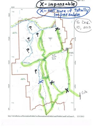
What shows on the map below as a black "X" is totally impassable, no amount of snow will allow for a crossing. The blue "X" may allow for a crossing with the snow there now, I just did not want to try it by myself with the light fading at 5 PM on Monday. And lots of snow, I was breaking trail in 24"-30" of powder.
Kaz Dog.....how was the snow coverage out there since the last two dumps?Also do you think as the area gets more snow through the season that some of the washouts might be passable?Either by using snow to build ramps or just from pain coverage?
- Thread starter
- #115
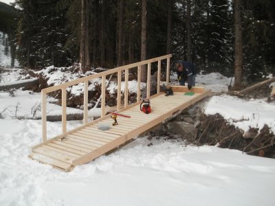
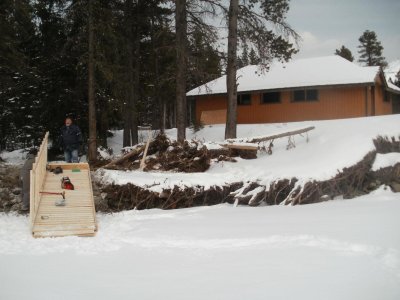
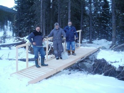
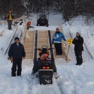
New Snowmobile Ramp at Cataract Creek parking lot! Tested and Sound! All snowmobilers with trailers please use this parking lot now, certainly not the road access at Etherington - as the parking area is so short/small, and the Lost Creek Road Gate area is limited.
Attachments
Last edited:
- Thread starter
- #116
Sunday, December 15, is the date of the next Trail Safety and Maintenance Day.We will meet in the Cataract Creek P.R.A. parking lot between 9:00 - 9:30 AM, and depart no later than 10:00 AM. Weather looks to be great, -1 to +2 by 2:00 PM.
- Thread starter
- #118
Powderface Trail out of Sibbald Flats (Dawson PRA), right off the #1 highway, can be excellent after a big snow. The Conservation Officers have told me that they have closed the Elbow Loop Trail at the "end" of Powderface due to destruction of the trail by the flooding. BUT the ride down to there is long and good, if they are not logging in there this winter, which I do not know at this point. Worth a stop.
Hey I'm driving through that area with two sleds and was thinking about stopping somewhere to ride! Is all of the kananaskis area destroyed? Is there anywhere to ride from calgary to can more you guys recommend?
retiredpop
Active VIP Member
New Snowmobile Ramp at Cataract Creek parking lot! Tested and Sound! All snowmobilers with trailers please use this parking lot now, certainly not the road access at Etherington - as the parking area is so short/small, and the Lost Creek Road Gate area is limited.
Looks good. I'm just wondering if it should have a railing on the other side as well. You know how some people have a tough time staying on a narrow bridge?
 Also kids will likely be driving across it as well and I'd hate to hear of someone falling off.
- Staff
- #120
New Snowmobile Ramp at Cataract Creek parking lot! Tested and Sound! All snowmobilers with trailers please use this parking lot now, certainly not the road access at Etherington - as the parking area is so short/small, and the Lost Creek Road Gate area is limited.
Hey I seen a set-up like that at another location North of there. Way North. Ours is larger and wider
Attachments
Similar threads

- Replies
- 445
- Views
- 67K
- Replies
- 4
- Views
- 3K
- Replies
- 199
- Views
- 17K
