Cougar Patch Staging Area - TWO HILLS/DUVERNAY

rknight111

Administrator
Administrator
Moderator
Joined
Sep 27, 2006
Messages
13,640
Reaction score
23,208
Location
Parkland County, AB and Valemount, BC
Website
www.snowandmud.com
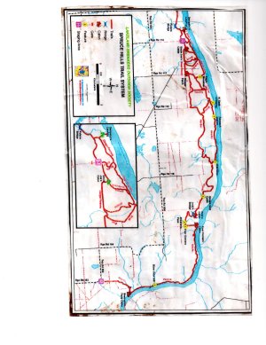
A very nice trail system, Some tough creek beds to cross, about 60 km trails to ride. 1hr 45 min from Edmonton, North East.

Riding Level:Some of the trail not recommended for beginners of Kids, large hills and creek beds can be challanging
Terrain: Hills, creek bed, river banks
Riding Surfaces: Mud, Clay, Muskeg, gravel, creeks, grass, tree roots on trals
Hazards: Long hills, uni-directional trails have to watch for un-comming traffic, odd tree on trail, creek beds can be hard to cross as its somtimes steep getting out. Rocks on trail


Directions: Hwy 16 East past Vegreville untill you see Hwy 36 North turn there,(North), Head 34Km then you will end up in Two Hills. Go straight through town to Hwy 45, turn east go 3.6 km (East) then turn left (North) on Hwy 36 North and head 5.9 km (North) and On the right you should be looking for Secondary Highway #637 (gravel road) head east down that road 6.5 km, you will go down a steep hill if your on the right road keep going straight when you gone the distance required you will be looking on your left for a Range Road sign, RR114, turn Left (North) this is a fairly narrow road when you come to the end thats the staging area. Park so other people can park as it is a small staging area.

duvernay, alberta - Google Maps
 
Last edited:
  • Thanks
Reactions: crp

Tanker336

Member
Joined
Jul 13, 2012
Messages
13
Reaction score
13
Location
Edmonton
Just a few pictures of the staging area at the Cougar patch.

001.jpg


002.jpg


003.jpg


004.jpg


005.jpg


006.jpg


007.jpg


008.jpg
 

rzrxpman

Member
Joined
Jul 14, 2012
Messages
18
Reaction score
8
Location
leduc, ab
this is a good trail, ride it alot, the high trail is alot easyer than the low trail, low trail is more for seasoned riders, very nice cabins along the way to take a break, have a snack and a pop,realy like this ride
 

rzrxpman

Member
Joined
Jul 14, 2012
Messages
18
Reaction score
8
Location
leduc, ab
its the same trail along the river going east/west, there is just a place where the trail forks, high trail is higher up from the river, low trail is closer to the river, little more hilly and muddy, they are pretty much paralelle with each other, if your riding west towards duvernay starting from the east end at the ferry crossing, stay left when the trail forks, thats the high trail, but try all the trail, its a good ride, might have to do a little winching on the low trail, but its not to bad, seen alot tuffer trails for sure, had a map of the trail, ill see if i still have it
 

rzrxpman

Member
Joined
Jul 14, 2012
Messages
18
Reaction score
8
Location
leduc, ab
img005.jpg
its the same trail along the river going east/west, there is just a place where the trail forks, high trail is higher up from the river, low trail is closer to the river, little more hilly and muddy, they are pretty much paralelle with each other, if your riding west towards duvernay starting from the east end at the ferry crossing, stay left when the trail forks, thats the high trail, but try all the trail, its a good ride, might have to do a little winching on the low trail, but its not to bad, seen alot tuffer trails for sure, had a map of the trail, ill see if i still have it
 

AB RANGER 007

Active VIP Member
Joined
Aug 1, 2008
Messages
451
Reaction score
201
Location
Vilna, AB,
Thanks any how. How come no one talks about the Rannach Provincial Grazing Reserve Recreational Access Map, that is in/for this area, like on the East side of the Staging area, and has a map of the trails, attached to the Grazing Access Map that runs between the Reserve and the River.(upper & lower trails), look for the blue trail lines. Oh by the way, did you get to do the Richardson Back Country ride yet.

Bruce.
 
Last edited:

steveo10

Active VIP Member
Joined
Oct 5, 2008
Messages
1,902
Reaction score
1,263
Location
Vermilion, Alberta
Website
www.facebook.com
im not 100% sure which trail your talking about but if its east it mite be the Myrnam trail.

i havent got around to making that trip yet but its on the bucket list!
 

AB RANGER 007

Active VIP Member
Joined
Aug 1, 2008
Messages
451
Reaction score
201
Location
Vilna, AB,
im not 100% sure which trail your talking about but if its east it mite be the Myrnam trail.

i havent got around to making that trip yet but its on the bucket list!

If you go to the (search for), The Rannach Provincial Grazing Reserve Recreational Access Map, zoom in on th upper LEFT corner (32) you will see a Blue Trail Line. N53.787474 W111.589127. That is the start of the Upper/Lower Trails that run to the East then South to its end. Except for the begining of this trail the rest of it, is inside the PRG Boundry. Would this be a no ride for quads/utv's area in the Summer months?? There is a fence that runs all the way around this PRG and in most places the trail is, in this area, between the fence and the river.?? I guess a call to the Land Office in St. Paul would answer my questions.

K B4 Y G. Bruce.
 

Tanker336

Member
Joined
Jul 13, 2012
Messages
13
Reaction score
13
Location
Edmonton
Rzrxpman,

Thanks for the PM regarding the map. I hope to hit the trails in the near future.

Tanker336
 

rzrxpman

Member
Joined
Jul 14, 2012
Messages
18
Reaction score
8
Location
leduc, ab
hey no problem, spread the wealth,lol, wish it wasnt so hard to get maps of trails, nobody seems to want to share info.....me n a buddy headin out there this saturday for a rip, hope its rainin!! LOL
 

AB RANGER 007

Active VIP Member
Joined
Aug 1, 2008
Messages
451
Reaction score
201
Location
Vilna, AB,
hey no problem, spread the wealth,lol, wish it wasnt so hard to get maps of trails, nobody seems to want to share info.....me n a buddy headin out there this saturday for a rip, hope its rainin!! LOL

All it takes is a Garmin Gps unit and some MapSource Mapping Software for your computer, then ride the trail's, then share, soon every one will have all the trails that can be ridden. If you read my post (#12) on this page, and follow the directions, you will see a pic/jpeg of the map from North of the Staging Area, East and then South, along the River to its end. the trails ( Upper and Lower) are in Blue. Zoom in and enjoy your ride.

K B4 Y G, Bruce.
 

rzrxpman

Member
Joined
Jul 14, 2012
Messages
18
Reaction score
8
Location
leduc, ab
All it takes is a Garmin Gps unit and some MapSource Mapping Software for your computer, then ride the trail's, then share, soon every one will have all the trails that can be ridden. If you read my post (#12) on this page, and follow the directions, you will see a pic/jpeg of the map from North of the Staging Area, East and then South, along the River to its end. the trails ( Upper and Lower) are in Blue. Zoom in and enjoy your ride.

K B4 Y G, Bruce.

thanks ranger, i am just learning the gps thing, i know the couger patch very well, ride it alot, i posted the map here a few posts back, if everyone shared what maps they have, would make things alot easyer, once i figger out this gps thing, ill add as many as i can, i ride alot of different areas, use what i read here someplace called" the trial and get lost method" lol,

would like to get to know a some people in the area that like riding same kinda trails as i do, wet, seems hard to get people together for a ride, im new to the area
 

AB RANGER 007

Active VIP Member
Joined
Aug 1, 2008
Messages
451
Reaction score
201
Location
Vilna, AB,
Hay rzrxpman, I saw your map, It doesnot show any referance to the R P G R P A Map, and since most of the trails to the North and to the East of the Staging Area are in the PRG Boundry, between the river and the North fence line, there coud be a conflick of Quad/UTV riding in this area, Mid-May to Mid-Oct. The snowmobiles are ok because the Grazing area is closed (no cattle), from Mid-Oct to Mid-May. Some clairification is needed, and since this is Provincial Recreation area as well as a Grazing Area, I am sure, it is a stay on the trail, riding area as well.


K B4 Y G, Bruce.
 

rzrxpman

Member
Joined
Jul 14, 2012
Messages
18
Reaction score
8
Location
leduc, ab
the trail is outside the fence, between the fence and the river, east staging area is on range road 203, east of fence, pretty sure west staging area is west of boundry, no cattle in the trail area, unless thier traned to stay without fences, lol, if the trail was closed may to oct pretty sure the local atv dealers wouldnt be have demo days/rides or pocker rallys either, but on by the sled club that looks after the trail, bought a membership from them last summer at the west staging area at the demo day ride, thats where i got the map, and there is noplace to leave the trail, heavy bush,
Hay rzrxpman, I saw your map, It doesnot show any referance to the R P G R P A Map, and since most of the trails to the North and to the East of the Staging Area are in the PRG Boundry, between the river and the North fence line, there coud be a conflick of Quad/UTV riding in this area, Mid-May to Mid-Oct. The snowmobiles are ok because the Grazing area is closed (no cattle), from Mid-Oct to Mid-May. Some clairification is needed, and since this is Provincial Recreation area as well as a Grazing Area, I am sure, it is a stay on the trail, riding area as well.


K B4 Y G, Bruce.
 

rzrxpman

Member
Joined
Jul 14, 2012
Messages
18
Reaction score
8
Location
leduc, ab
if you look on the grazing reserve map you mentioned earlyer, you see the trail is a purple line , all north and east of the fence lines, the west staging is west of secion 20, end of range road 114, range road 114 runs along west side of border, i ride this trail alot, its not closed, i just moved from that area in march
the trail is outside the fence, between the fence and the river, east staging area is on range road 203, east of fence, pretty sure west staging area is west of boundry, no cattle in the trail area, unless thier traned to stay without fences, lol, if the trail was closed may to oct pretty sure the local atv dealers wouldnt be have demo days/rides or pocker rallys either, but on by the sled club that looks after the trail, bought a membership from them last summer at the west staging area at the demo day ride, thats where i got the map, and there is noplace to leave the trail, heavy bush,
 

rzrxpman

Member
Joined
Jul 14, 2012
Messages
18
Reaction score
8
Location
leduc, ab
sorry for the typo, east staging is on range road 103
the trail is outside the fence, between the fence and the river, east staging area is on range road 203, east of fence, pretty sure west staging area is west of boundry, no cattle in the trail area, unless thier traned to stay without fences, lol, if the trail was closed may to oct pretty sure the local atv dealers wouldnt be have demo days/rides or pocker rallys either, but on by the sled club that looks after the trail, bought a membership from them last summer at the west staging area at the demo day ride, thats where i got the map, and there is noplace to leave the trail, heavy bush,
 
Top Bottom