spitfire
Active member
Heading out tomorrow and was just wondering which off loading and riding area would be the best. thanks


Heading out tomorrow and was just wondering which off loading and riding area would be the best. thanks
Heading out tomorrow and was just wondering which off loading and riding area would be the best. thanks
Me and a bud might be coming down this weekend. We don't know the area too well and in the past we've staged at the Corbin townsite went south then east.
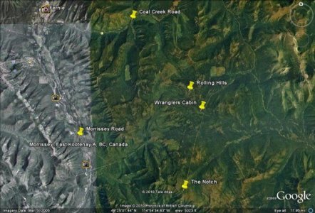
These Rolling Hills - where is it? Guessing Marten Ck or the Coal Ck pass? Sounds like it's west of the Corbin road before you get to the townsite.
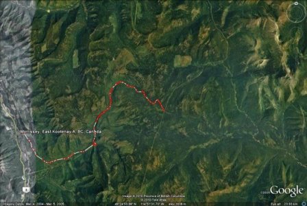
Also I'm trying to guesstimate where 24km is on Morrissey Rd. This path on GglEarth is 20km long and I hit a T-intersection - do I go N or S here, or am I way off?
Me and a bud might be coming down this weekend. We don't know the area too well and in the past we've staged at the Corbin townsite went south then east.
These Rolling Hills - where is it? Guessing Marten Ck or the Coal Ck pass? Sounds like it's west of the Corbin road before you get to the townsite.
Also I'm trying to guesstimate where 24km is on Morrissey Rd. This path on GglEarth is 20km long and I hit a T-intersection - do I go N or S here, or am I way off?
") Give a wave if you see us this weekend - black Renegade and black Summit XP. And sorry for the threadjack spitfire.
Give a wave if you see us this weekend - black Renegade and black Summit XP. And sorry for the threadjack spitfire.You can get into the Rolling Hills from Corbin, but that's the long way. Never been myself, but have seen the pipeline from on top of the rolling hills on a clear day. The Morrissey trail takes you right past the far south end of the hills.
IMO, not an area that's great if visibility gets bad. People with a poor sense of direction could easily get confused and it would a long time before you found your way out.

AVALANCHE !!!! Was out to the notch on friday and there was a small slide near the notch....the wind is drifting over the top and there is overhanging drifts. Just thought everyone should know,,,, BE CAREFULL!!!!