Google Earth GPS

oler1234

Active VIP Member
Joined
Nov 20, 2008
Messages
3,602
Reaction score
6,046
Location
Calgary, AB & Golden, BC
Do they make one yet?? Would love to have a GPS with the satalite images on it. cant really use my phone as we all know.... no coverage. Anyone know if this is even avalible yet? Garmin topo canada is good, but to have the images would be top notch
 

Summiteer

Active VIP Member
Joined
Nov 8, 2006
Messages
5,883
Reaction score
3,508
Location
Whitecourt, Ab
Ipad must have an app...I'd think most GPS screens would be too small to show any sort of decent satellite image.
 

ferniesnow

I'm doo-ing it!
Joined
Dec 2, 2008
Messages
108,870
Reaction score
83,182
Location
beautiful, downtown Salmon Arm, BC
Do they make one yet?? Would love to have a GPS with the satalite images on it. cant really use my phone as we all know.... no coverage. Anyone know if this is even avalible yet? Garmin topo canada is good, but to have the images would be top notch

Maybe this Rino 655T is the baby!

The device also supports (subscription required), that lets you download satellite images to your device and integrate them with your maps.


Just went to the Garmin website and found that. Not available until the 3-4th quarter of 2011, so it should be close.
 

sled-fiend

Active VIP Member
Joined
Aug 7, 2008
Messages
213
Reaction score
215
Location
Victoria, British Columbia
Website
www.raintek.ca
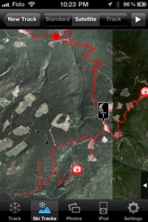
If you have an iPhone get the app "ski tracks" you don't need reception to use it and it has real time satellite imagery. Better then any hand held I've had in the past including the Oregon 550T. Also take photos to mark waypoints. Buy now and thank me later;)
 

sled-fiend

Active VIP Member
Joined
Aug 7, 2008
Messages
213
Reaction score
215
Location
Victoria, British Columbia
Website
www.raintek.ca
Here is a screen shot of the app
 

Attachments

  • ImageUploadedByTapatalk1315805235.979828.jpg
    ImageUploadedByTapatalk1315805235.979828.jpg
    64.1 KB · Views: 302

mountainbigbull

Active VIP Member
Joined
Nov 25, 2006
Messages
335
Reaction score
135
Location
Cochrane Alberta
This iPhone app looks pretty cool but it is my understanding that cell phones interfere with beacons. Just keep this in mind and i would suggest keeping your phone on your sled if powered up.
 

imdoo'n

Active VIP Member
Joined
Jan 15, 2008
Messages
57,282
Reaction score
50,388
Location
alberta
Maybe this Rino 655T is the baby!

The device also supports (subscription required), that lets you download satellite images to your device and integrate them with your maps.


Just went to the Garmin website and found that. Not available until the 3-4th quarter of 2011, so it should be close.


was told they can order this week after the 14th, fwiw.
 

AB RANGER 007

Active VIP Member
Joined
Aug 1, 2008
Messages
451
Reaction score
201
Location
Vilna, AB,
oler1234, if you think Garmin Topo Canada V4 is good, you would be impressed with the ibycus Topo canada V4, Dale Atkin out of Calgary, $25.00 for all of Canada, 3.4+- gig's, Garmin compatable, it has the North West Calgay BY-Pass, Hwy 201 on it, as well as the air port that looks like an air port, not just a small picture of a Airplane in a large blank space.
As far as Google Earth goes, it is great if the area of your interest is in High Res. The images we see to day are Up to 5 years old ++, not real time. The current Calgary image is 09/13/2008. We could not afford REAL TIME images.???? I have a Garmin Oregon 550 and took out the Birds Eye subscription but some of the areas of my interest are in LOW RES so it was of no use to me, but they do not tell you these kind of things.

Bruce.
 

X-it

Active VIP Member
Joined
Jan 8, 2007
Messages
7,343
Reaction score
16,443
Location
Prince George
Yes they do, you will need to by the magellan explorist 610 canadian then by a subscription to digital globe for 29 dollars. Plus the camera, video and voice recording. As well as voice turn by turn city navagation. It as barometric altimeter or gps alt. and electronic compass. 4gb of memory with 32gb sd that can be added. I paid 299 for mine from canadiantire. It comes preloaded with topo world maps and also topo canada maps. Digital globe gives you high def downloads for anywhere in the world
 
Last edited:

Ohmz

Active member
Joined
Feb 3, 2007
Messages
93
Reaction score
65
Location
Edmonton
i have a rino 650 and i tried some demo d/ls of birds eye and some higher population areas were good res. but all the areas for sledding were IMO not worth the fee... espically when you can d/l any topo map for free
 

X-it

Active VIP Member
Joined
Jan 8, 2007
Messages
7,343
Reaction score
16,443
Location
Prince George
I was not aware of any topo maps for free that would work with a gps, what programs are you referring to? 29 dollars is not a lot to pay to get high def imagery for any where in the world.
 

AB RANGER 007

Active VIP Member
Joined
Aug 1, 2008
Messages
451
Reaction score
201
Location
Vilna, AB,
X-it, I have a Garmin Oregon 550, and purchased the Birds Eye for $29.00+-, and some of the areas of my interest are in Low Res, so I to, not happy with this application as well, and will not be renewing it. Any where in the World is fine but not in your back yard sucks. If you do some searching, you might find some of " ibycus" Mapping FREE off the net. His (Dale Atkin's) Topo Canada V4 at 3.5 +- gig's covers all of Canada., and is configured for the Garmin MapSource (gdb). Oh by the way for $25.00 you can order a copy of this from his site. Do a search on " ibycus." His earlier V2.1 is also VG.
I have most of the Canadian Garmin Mapping Software and other as well that is configured for the Garmin MapSource Software except the "OIL FIELD" Software's, too much money for my use. Backroad Gps Maps prices are bad enough, at $275.00 for Alberta and BC, but good, lots of color.
Bruce.
 
Last edited:

X-it

Active VIP Member
Joined
Jan 8, 2007
Messages
7,343
Reaction score
16,443
Location
Prince George
Well magellan uses a program called digitalglobe. If you go on google earth and scroll down on the left you can find digitalglobe coverage areas. But for some unknown reason the digitalglobe magellan uses is more up to date than google earths. But for the most part what ever you view on google earth is what you see on your gps, so go to your special areas on google earth and see if it is clear enough. To bad i got ride of most of my garmins or i would have downloaded birds eye and compared it with magellans, but who knows maybe you will. If you want to see what it looks like go to the magellan web site and download vantagepoint and see for yourself..it is free. I have etopo maps which i print out.. it is 1:50000 topo maps for back up. I looked at ibycus. But hey it cost me 440 dollars for etopo bc so i am going to stick with it. It also works with my gps, but i prefer digitalgobe instead.
 
Last edited:

AB RANGER 007

Active VIP Member
Joined
Aug 1, 2008
Messages
451
Reaction score
201
Location
Vilna, AB,
Thanks for clearing this up, if you had mentioned that you were using a Magellan GPS unit I would not have taken up your time. But I did supply a answer to your question, for free Topo Maps that work with a GPS, some of them can be down loaded off of Torrent. They just happen to a different brand that you are using. Also in my collection of Mapping Software, I have a Magellan MapSend Topo Canada, a 2 CD disk set, that I used for a reference between the different MAPS, as well as the Lowrance MapCreate Canada Topo V6.a 4 CD disk set, when I puchased this I was using a Lowrance GPS model Global Map 100 and then someone gave me a Lowrance iFinder Explorer, And after waiting a very long time for Lowrance to update their mapping, I changed to Garmin, at witch time I have a older Garmin model GPS V, a recent GPSmap 60 CSX, and a new Oegon 550, witch uses a new Garmin program called Base Camp in a GPX file instead of the Garmin MapSource GDB file. My first GPS unit, witch I still have, was a 1994 EAGLE AccuNav SPORT, NO MAPS, just tracks and waypoints, and cost me $749.00 and needed 6 AA bateries to run it=9volts and when it got down to 6 volts, it asked to replace the batteries.
I also use the Ozi Explorer Program along with 10+ much out of date, SPECTRUM DIGITAL IMAGING CANADIAN (mostley Alberta Maps from 1974 to 2000), MAPS, 40 maps to a CD on the first release the 80 maps on the second , that are configured for the Ozi program. I did not buy all of these, I obtained most from a friend on a shaired agreement.

Bruce.
 

X-it

Active VIP Member
Joined
Jan 8, 2007
Messages
7,343
Reaction score
16,443
Location
Prince George
Ha ha lots of .... well at least you have the 550 now. etopo has since lowered their price you can get all of alberta for a 100 bucks from map town. It is good to take along a printed map and a compass just incase.
 
Top Bottom