
You are using an out of date browser. It may not display this or other websites correctly.
You should upgrade or use an alternative browser.
You should upgrade or use an alternative browser.
Weather Advisory Thread
- Thread starter Trashy
- Start date

- Staff
- #82
- Joined
- Oct 21, 2006
- Messages
- 48,007
- Reaction score
- 32,148
- Location
- Edmonton/Sherwood Park
- Website
- www.bumpertobumper.ca
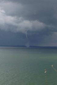
SERIOUS TORNADO ALERTS ISSUED FOR DEVON THROUGH EDMONTON, ST ALBERT AND NORTHWARD....... http://www.theweathernetwork.com/weather/canada/alberta/edmonton
- Staff
- #83
- Joined
- Oct 21, 2006
- Messages
- 48,007
- Reaction score
- 32,148
- Location
- Edmonton/Sherwood Park
- Website
- www.bumpertobumper.ca
- Moderator
- #84
- Moderator
- #85
Bogger
Bogger of the GBCA
Loonie size hail @ whitemud crossing....
plio7
GBCA Member
Missed Onoway...... Booooo
snopro
Active VIP Member
Anybody suddenly find themselves posting from Kansas with Dorothy and Toto?
- Staff
- #88
- Joined
- Oct 21, 2006
- Messages
- 48,007
- Reaction score
- 32,148
- Location
- Edmonton/Sherwood Park
- Website
- www.bumpertobumper.ca
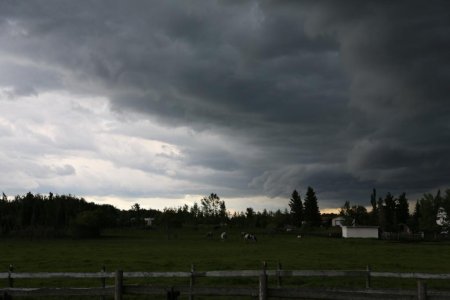
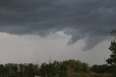
FROM OUTSIDE THE FRONT OF OUR SHOP:
snopro
Active VIP Member
FROM OUTSIDE THE FRONT OF OUR SHOP:
Not good when you see a hint of green in the clouds Rick. Batten down the hatches..
- Staff
- #91
- Joined
- Oct 21, 2006
- Messages
- 48,007
- Reaction score
- 32,148
- Location
- Edmonton/Sherwood Park
- Website
- www.bumpertobumper.ca
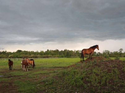
IT WAS QUITE SURREAL.... ALMOST DEJA VOUS FROM "BLACK FRIDAY"iTHE BIG TORNADO YEARS AGO) .... LOTSA WIND, RAIN AND HAIL, BUT NO TORNADOSNot good when you see a hint of green in the clouds Rick. Batten down the hatches..
") ....... ALL THE PLANTS AT HOME SURE TOOK A BEATING THOUGH
....... ALL THE PLANTS AT HOME SURE TOOK A BEATING THOUGH Iron Horse Racing
Active VIP Member
Polaris Lady
Active member
Public AlertsMarine AlertsSpecial Weather Statements
Watches
Elk Valley
10:31 AM PDT Tuesday 18 June 2013
Severe thunderstorm watch for
Elk Valley continued
Severe thunderstorms are possible today.
This is an alert to the potential development of severe thunderstorms with large hail and damaging winds.
Monitor weather conditions..listen for updated statements. If threatening weather approaches take immediate safety precautions.
Conditions are favourable for the development of thunderstorms today across portions of the central and northern interior as well as sections of the Eastern Kootenays. The potential exists that some of these thunderstorms may become severe this afternoon. The main threats from these storms are large hail, damaging wind gusts, intense lightning, and heavy downpours.
DaveB
Active VIP Member
We get that warning every day in Alberta now. It's like the meteorologists don't even try any more....
Polaris Lady
Active member
I just got a notice from drive bc saying highway 3 is closed 20 km east of sparwood due to a rock slide in Alberta. I can't find any info on it yet. Other than no detour.
snopro
Active VIP Member
Tornado warnings down by Elkwater and Foremost earlier. Confirmed twister near Elkwater now they say.
snopro
Active VIP Member
Clouds are moving low and fast from the SE. Could be having bad weather here in short time.
Public AlertsMarine AlertsSpecial Weather Statements
Warnings
M.D. of Willow Creek near Claresholm and Stavely
9:57 PM MDT Wednesday 19 June 2013
Severe thunderstorm warning for
M.D. of Willow Creek near Claresholm and Stavely ended
M.D. of Willow Creek near Nanton and Parkland
9:57 PM MDT Wednesday 19 June 2013
Severe thunderstorm warning for
M.D. of Willow Creek near Nanton and Parkland ended
Okotoks - High River - Claresholm
10:08 PM MDT Wednesday 19 June 2013
Rainfall warning for
Okotoks - High River - Claresholm continued
Heavy rainfall tonight and Thursday.
A low pressure system is slowly moving into Southwestern Alberta bringing heavy rain and the potential for severe thunderstorms. This evening thunderstorms have developed across Southern Alberta and are moving westward this evening. These thunderstorms have the potential to produce large hail, strong winds, heavy rain and a risk of a tornado.
Tonight rainfall will intensify along the foothills as the low pressure centre moves into Southern Alberta. Heaviest rainfall is expected tonight with amounts of 50 to 70 millimetres possible in some locations. Total amounts of 100 millimetres are likely by Thursday evening. Some areas of the foothills may see up to 150 millimetres by the time the system begins to weaken Thursday night.
Watches
Okotoks - High River - Claresholm
10:08 PM MDT Wednesday 19 June 2013
Severe thunderstorm watch for
Okotoks - High River - Claresholm ended
Public AlertsMarine AlertsSpecial Weather Statements
Warnings
City of Calgary
10:08 PM MDT Wednesday 19 June 2013
Rainfall warning for
City of Calgary continued
Heavy rainfall tonight and Thursday.
A low pressure system is slowly moving into Southwestern Alberta bringing heavy rain and the potential for severe thunderstorms. This evening thunderstorms have developed across Southern Alberta and are moving westward this evening. These thunderstorms have the potential to produce large hail, strong winds, heavy rain and a risk of a tornado.
Tonight rainfall will intensify along the foothills as the low pressure centre moves into Southern Alberta. Heaviest rainfall is expected tonight with amounts of 50 to 70 millimetres possible in some locations. Total amounts of 100 millimetres are likely by Thursday evening. Some areas of the foothills may see up to 150 millimetres by the time the system begins to weaken Thursday night.
Warnings
M.D. of Willow Creek near Claresholm and Stavely
9:57 PM MDT Wednesday 19 June 2013
Severe thunderstorm warning for
M.D. of Willow Creek near Claresholm and Stavely ended
M.D. of Willow Creek near Nanton and Parkland
9:57 PM MDT Wednesday 19 June 2013
Severe thunderstorm warning for
M.D. of Willow Creek near Nanton and Parkland ended
Okotoks - High River - Claresholm
10:08 PM MDT Wednesday 19 June 2013
Rainfall warning for
Okotoks - High River - Claresholm continued
Heavy rainfall tonight and Thursday.
A low pressure system is slowly moving into Southwestern Alberta bringing heavy rain and the potential for severe thunderstorms. This evening thunderstorms have developed across Southern Alberta and are moving westward this evening. These thunderstorms have the potential to produce large hail, strong winds, heavy rain and a risk of a tornado.
Tonight rainfall will intensify along the foothills as the low pressure centre moves into Southern Alberta. Heaviest rainfall is expected tonight with amounts of 50 to 70 millimetres possible in some locations. Total amounts of 100 millimetres are likely by Thursday evening. Some areas of the foothills may see up to 150 millimetres by the time the system begins to weaken Thursday night.
Watches
Okotoks - High River - Claresholm
10:08 PM MDT Wednesday 19 June 2013
Severe thunderstorm watch for
Okotoks - High River - Claresholm ended
Public AlertsMarine AlertsSpecial Weather Statements
Warnings
City of Calgary
10:08 PM MDT Wednesday 19 June 2013
Rainfall warning for
City of Calgary continued
Heavy rainfall tonight and Thursday.
A low pressure system is slowly moving into Southwestern Alberta bringing heavy rain and the potential for severe thunderstorms. This evening thunderstorms have developed across Southern Alberta and are moving westward this evening. These thunderstorms have the potential to produce large hail, strong winds, heavy rain and a risk of a tornado.
Tonight rainfall will intensify along the foothills as the low pressure centre moves into Southern Alberta. Heaviest rainfall is expected tonight with amounts of 50 to 70 millimetres possible in some locations. Total amounts of 100 millimetres are likely by Thursday evening. Some areas of the foothills may see up to 150 millimetres by the time the system begins to weaken Thursday night.
- Staff
- #99
- Joined
- Oct 21, 2006
- Messages
- 48,007
- Reaction score
- 32,148
- Location
- Edmonton/Sherwood Park
- Website
- www.bumpertobumper.ca
[h=5]The Weather Network
[/h][h=5](Alex) A scary situation is unfolding in southern Alberta this morning as days of heavy rain have caused rivers to spill their banks.
The latest evacuations, states of emergency and road closures are being updated at this link: http://oak.ctx.ly/r/6jk1
Photo: Cougar Creek in Canmore via Jeff Adams
[/h]
drew562
Active VIP Member
It's pics like that that make me wonder why they worry about atv crossings at creeks so much. The water shed damage in the foot hills is crazy. I've seen storms at nordegg level 5' deep creeks into 100' wide and 1/2" deep creeks in one days rain. The fish are taking a beating In that. Hopefully no homes are affected.
Similar threads
- Replies
- 6
- Views
- 2K