Thank you Avalanche.ca

JONSHOW

Active member
Joined
Oct 12, 2013
Messages
99
Reaction score
88
Location
Tumbler Ridge, BC
Just home from a quick ride out to the Wolverine in TR.
Got to the new warm up shack built by volunteers from our very small club and saw this great sign.
Specific terrain map of our sweet little area.
Thank you so much avalanche.ca (and Recreation Sites and Trails BC), i'm sure this sign was donated by the society, group, association.
Anyone who rides up this way and can relay info to avalanche.ca please do.
Only a general report from the website right now on "overall" general conditions.
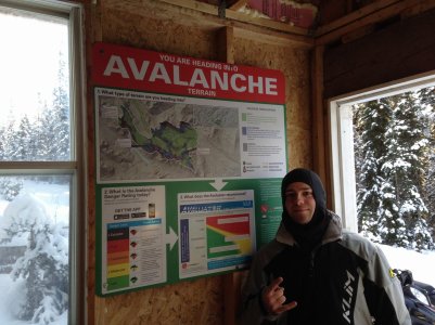
Wolverine Avy Sign.jpg
 
Last edited:

X-Treme

Active VIP Member
Joined
Sep 27, 2014
Messages
2,832
Reaction score
4,141
Location
Strathcona County
Website
www.robinsautomotive.ca
Just home from a quick ride out to the Wolverine in TR.
Got to the new warm up shack built by volunteers from our very small club and saw this great sign.
Specific terrain map of our sweet little area.
Thank you so much avalanche.ca, i'm sure this sign was donated by the society, group, association.
Anyone who rides up this way and can relay info to avalanche.ca please do.
Only a general report from the website right now on "overall" general conditions.
View attachment 180604

The cabin at Bell in McBride has the same thing. I'm guessing that they're likely pretty common in the cabins.
 

JONSHOW

Active member
Joined
Oct 12, 2013
Messages
99
Reaction score
88
Location
Tumbler Ridge, BC
The cabin at Bell in McBride has the same thing. I'm guessing that they're likely pretty common in the cabins.
If that is the case, awesome.
This sign is up in a shack that is only a few months old and no such sign existed in the old shack.
Anyone know if there is a similar sign out at the Hot Dog Stand at Babcock. (That'd be coo.)
 

ferniesnow

I'm doo-ing it!
Joined
Dec 2, 2008
Messages
109,130
Reaction score
83,434
Location
beautiful, downtown Salmon Arm, BC
Not to burst anyone's bubble but aren't those ATES maps (Avalanche Terrain Assessment Maps) put out by BC Recreation and Trails? It is great to see these throughout the province in the areas where there are high risks from avalanches. Just the fact that they are there will get people to read them and be more aware. Great job by all concerned.
 

moyiesledhead

Active VIP Member
Joined
Oct 12, 2008
Messages
5,435
Reaction score
10,775
Location
Moyie B.C.
Not to burst anyone's bubble but aren't those ATES maps (Avalanche Terrain Assessment Maps) put out by BC Recreation and Trails? It is great to see these throughout the province in the areas where there are high risks from avalanches. Just the fact that they are there will get people to read them and be more aware. Great job by all concerned.

Yup. Paid for by the BC Government. Our tax dollars doing something useful for a change.
 

JONSHOW

Active member
Joined
Oct 12, 2013
Messages
99
Reaction score
88
Location
Tumbler Ridge, BC
Not to burst anyone's bubble but aren't those ATES maps (Avalanche Terrain Assessment Maps) put out by BC Recreation and Trails? ...Great job by all concerned.
It must be a partnership between groups.
Thank you to all involved.
 

briguy99

Active VIP Member
Joined
Oct 11, 2007
Messages
893
Reaction score
572
Location
Pritchard, British Columbia, Canada
The BC Recreation and Trails division of the government has been nothing but a pleasure to work with!! Our regional rep here in Kamloops is easily approachable and rides a sled!! Also the Minster responsible rides herself and is pro ORV.....she's on our side!!

This in combination with Avalanche Canada they have mapped out alot of Avy Terrain in the popular riding areas to give us this great tool in making even more responsible decisions to manage risk in the backcountry (ATES maps)......money well spent!!
 

Absledder

Active VIP Member
Joined
Oct 29, 2013
Messages
756
Reaction score
669
Location
bonnyville
Good to see the north Rockies getting some attention! Most of the time theres no specific Avy bulletin just a general report
 
Top Bottom