mapping software - what do you use?

wayupnorth

Member
Joined
Dec 3, 2010
Messages
12
Reaction score
0
Location
Fort Vermilion / La Crete, alberta
i recentlly picked up a Garmin Etrex Legend HCx for taking with me on my quad and on my sled.

but now that im looking at it im thinking that i need some mapping software.

i called Maptown in edmonton and asked them about the garmin topo maps for western canada or the Fugawi ones and i was suprised when the fella told me that i wouldnt like either.

he recomended Bush Maps and Backroad GPS, either one he said would be better for quading, sledding and hunting.

now, seeing that they are all 150-250 bucks a shot, i figured i should maybe ask around and see what other people are using and what they would recomend.
cause i only wanna get yelled at from the wife once for this, hehe.

so if anyone has any input into which one is better and why i would LOVE to hear from ya.

thanks for your time.

oh, here is a link to the maptown website that shows the mapping software that they recomended, and those they didnt as well, in case anyone else is looking for the same info that i was.

Digital Software | Map A Mia!
 

paulw22

Active VIP Member
Joined
Nov 29, 2008
Messages
277
Reaction score
84
Location
Grande Prairie
I think Mapsource is free or it comes with the Garmin, that would be your Program to comunicate with your garmin, I have Topo Canada V4 maps, they are good and have all of Canada in there. I dont think anyone has mapped up your way very well so even if its called "back country" it may not have anything up there. If you use Google earth you could create tracks based on the air photos, then upload them to your GPS and find you way around like that.

Paul
 

AB RANGER 007

Active VIP Member
Joined
Aug 1, 2008
Messages
451
Reaction score
201
Location
Vilna, AB,
wayupnorth If you care to PM me your eMail address, I can help you out. I do not send JPEG'S/pictures on FORUMS, A little short on computer skills. But now how to eMail and I like the spell check thingy.

Bruce.
 

AB RANGER 007

Active VIP Member
Joined
Aug 1, 2008
Messages
451
Reaction score
201
Location
Vilna, AB,
I think Mapsource is free or it comes with the Garmin, that would be your Program to comunicate with your garmin, I have Topo Canada V4 maps, they are good and have all of Canada in there. I dont think anyone has mapped up your way very well so even if its called "back country" it may not have anything up there. If you use Google earth you could create tracks based on the air photos, then upload them to your GPS and find you way around like that.

Paul

There is a person in Calgary, Dale Atkin is his name, goes by ibycus. Do a search, ibycus.com/ibycus topo. He has a TOPO CANADA Version 3.2 out and available for a donation of $25.00 it is big, 3.4 Gigs+- for all of Canada. And :rolleyes:yes there is a lot stuff on this software that is not on Garmin's Topo canada V4 North of FT. Vermillion. If you have the computer smarts you can download it from ETorrent FREE, takes +- 15-20 hrs. to download. There is also a free non topo for all of the USA. that he put together.

Bruce
 

Wingwalker

Active VIP Member
Joined
Nov 25, 2009
Messages
240
Reaction score
113
Location
Beiseker Alberta
i recentlly picked up a Garmin Etrex Legend HCx for taking with me on my quad and on my sled.

but now that im looking at it im thinking that i need some mapping software.

i called Maptown in edmonton and asked them about the garmin topo maps for western canada or the Fugawi ones and i was suprised when the fella told me that i wouldnt like either.

he recomended Bush Maps and Backroad GPS, either one he said would be better for quading, sledding and hunting.

now, seeing that they are all 150-250 bucks a shot, i figured i should maybe ask around and see what other people are using and what they would recomend.
cause i only wanna get yelled at from the wife once for this, hehe.

so if anyone has any input into which one is better and why i would LOVE to hear from ya.

thanks for your time.

oh, here is a link to the maptown website that shows the mapping software that they recomended, and those they didnt as well, in case anyone else is looking for the same info that i was.

Digital Software | Map A Mia!

Download the Ibycus software its much better than the Garmin topo

Home

He also has some you tube videos on his site on how to use it

Use u torrent to download it

http://www.utorrent.com/
 

wayupnorth

Member
Joined
Dec 3, 2010
Messages
12
Reaction score
0
Location
Fort Vermilion / La Crete, alberta
wowsers.

i spent 4 hours tonight trying to get that Ibycus program.

the email address on the Ibycus web site isnt working (for me at least) so i cant order the 3.2 from him.

so i went with the Torrent route and after hours of searching finally found a site that at least had the 2.1 version.

so that is DLing as i type.

if anyone knows a site (that WORKS) to get the 3.2 maybe post it here for us (me :)) as im sure i wont be the last person looking for a current DL site for this.

the readings i looked at on line everyone was saying how good the program is, so im very excited to get it and have a look at it.

hope to get it and get it up and running before the sled trip to go ice fishing!

thanks again for all your help guys (gals)
 

bushboy

Active member
Joined
Nov 7, 2006
Messages
39
Reaction score
11
Location
NW Alberta
I cant speak to Icybus as I ran into the same issues re: finding an active d/l link and I'm not comfy with google searches, however, if it is a compilation of federal maps it wont do you much good in our area ( La Crete, Ft V, High Level) as the feds havent updated the topo maps since the sixties and seventies (If I am wrong please correct me, but I d/l the fed topo maps myself about five yrs ago and thats what I got).

Backroads mapbooks are pretty good, even for up North here, but they are not infallible. For a quick and easy I would go with them. Another good choice is Oiltrax...available at your local radio communications store in High Level.

I use both, but mostly use 30 yrsof local knowledge combined with OziExplorer and some liberated sattelite photos. Not sure how well you know the area, but some of the winter accesses can change around from year to year depending on logging locations and oil company whims. Keep and organizr your tracks. They become very useful after a couple of years of gathering info. Another good source is the local logging companies woodlands operations if you are connected.

Edit Bush maps is, I believe, an offshoot of Patch Map. I havn't used it, but I tried Patch Map a couple of yrs ago and found that the stripped down (affordable) version wasn't very helpful. Oiltrax was better for me.
 
Last edited:

blar

Active member
Joined
Jan 14, 2009
Messages
138
Reaction score
117
Location
Edmonton
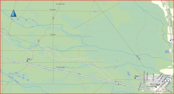
What detail is missing?
 

Attachments

  • high level.jpg
    high level.jpg
    43.5 KB · Views: 400

AB RANGER 007

Active VIP Member
Joined
Aug 1, 2008
Messages
451
Reaction score
201
Location
Vilna, AB,
What detail is missing?

blar, if you care to PM me your eMail Address I will send you the same picture, from Backroads Mapbook Garmin GPS Software. I am not saying that you run out and spend $150.00 on it at this time but they are working on a UPDATE to correct a lot of Small Problems. Except for the Smowmobile/Quad/Walking Trails, :rolleyes: I do not think that it is any better than the ibycus,V2.0 Beta, V.2.1 or the V.3.2, I do not have the V3.2, but I do have the V3.0 that was out for a short time but there was an :eek: error, no BLUE
display on the computer screen but was on the color display GPS units, and that is why there is a V3.2. Dale Atkin (ibycus) made this correction right away.:cool:

Bruce.
 

bushboy

Active member
Joined
Nov 7, 2006
Messages
39
Reaction score
11
Location
NW Alberta
Blar
Is that from Ibycus? As I said I could not d/l it so I have not seen it to comment.

As to your image it is a good enough generic base, but I guess it depends what one needs. I see that the trail indicated in white running se-nw just W of High Level is doubled up and inaccurate (It is one of the snowmobile trails and only one exists. Cutlines shown are old data (ie 40 or more years) and do not reflect current access. There are more snowmobile trails than shown. There is a network of pipelines and gas wells in the area that is not shown. Some of the watercourses could be debated (although it is so flat that flows sometimes go two ways out of slough areas), The water fill shown along HWY 58 is now and has been for a number of years a gun range. There is no water fill in the swamp immediately NW of High Level.

I dont know about Ibycus and am not commenting on it. My comments are about the mapping products supplied by the feds for free. The maps are better than nothing, but better solutions exist. It just depends what ones needs are. The federal maps won't get you into Bistcho or Thurston Lake for example, but they will provide a nice background for live tracking. It can be fun to compare the map data to what you see in front of you.

Not wanting to fight. I always have room on my laptop for another mapping/gps tool. :)
 

AB RANGER 007

Active VIP Member
Joined
Aug 1, 2008
Messages
451
Reaction score
201
Location
Vilna, AB,
Hey bushboy, do you have a track/trail into the Thurston Lake Provincial Forest Recreation Area. N 59.94281 W 118.10998. I did a vertual trip on the Spawn Lake/Bistcho Lake ATV & SNOW ROUTE TRAIL, this afternoon from the Zama Road. N 59.12700 W 118.31863. Also is there a track/trail over to the Bistcho Lake further to the west. Is this ride doable in the summer or just in the winter.
Thanks.

Bruce.
 

bushboy

Active member
Joined
Nov 7, 2006
Messages
39
Reaction score
11
Location
NW Alberta
Unfortunately I lost my track to Thurston. I can recreate it fairly close, but there is a portion of it where my sattelite photos kind of grey out due to lack of features in the muskeg. There was summer access (argo and lots of work) but I am pretty sure that trail has grown in now. There is winter access from Indian Cabins area, but most years one must snowmobile the last 20-40 km (rough back country ride, bring friends lol) and the first 20-40 km is winter road access. I could recreate most of that route on a track if you wanted (Oziexplorer). There is a route across between Thurston & Bistcho, but I have not done it. I have talked to mlocal trappers and outfitters that have and could maybe figure it out. The trail you mention (backroads?) exists, but is in fact an old access to Bistcho from the sixties. I have been part way up it in the past but generally Bistcho is accessed from North of Zama City along one of two routes. Summer access is possible on quads, but it is rough country with creek crossings and muskeg. Winter access can range from snowmobile to truck depending on oil and logging activity. I have tracks for these main routes.
 

AB RANGER 007

Active VIP Member
Joined
Aug 1, 2008
Messages
451
Reaction score
201
Location
Vilna, AB,
bushboy, Thanks for your return and thank you for your offers, but as I likely will never travel to this area in the winter, it will not be necessary for you to take the time to work out the maps. (no snowmobile), and I will not be putting in for the Bison draws for that area when you can hunt them all year along the South/West border of the WBNP, North of highway 58, North to the Caribou Mtns Wildland Provincial Park. I was up there in 1999 as a non Hunting guest, before the Provincial Park was established.
Thanks again, Bruce
 

giddyup

Active VIP Member
Joined
Oct 8, 2008
Messages
403
Reaction score
206
Location
saskatchewan
this all looks good just one problem, some of us are on mac's any one have any advice to do any of this on a mac
thanks
 
Top Bottom