Horseshoe (Blue River)

ronmexico

Active VIP Member
Joined
Feb 22, 2008
Messages
367
Reaction score
205
Location
Beaumont
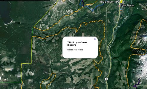
I remember back in 2010 this area was going to become part of the managed area's and was shown on the hand drawn maps. I believe the road had been de-activated and a bridge pulled out making access impossible.
Is there hope for this area ever becoming activated?

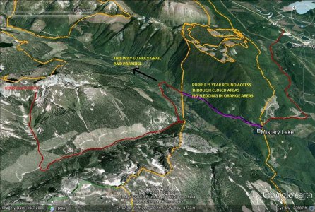
Curious if there is any talk of other new area's being given to the club to add to the managed area's?
 

sscamaro_skwark

Active member
Joined
Mar 19, 2011
Messages
77
Reaction score
49
Location
Lloydminster
I still have maps that also said it was going to be re-activated but Robin didn't know anything about that (Holy Smoke Inn)
They had to fight hard just to keep what is currently open so between tree huggers & Heli skiing I doubt it
They don't even groom the trail into Whitewater, Paradise, Big Blue, & Holy Grail because of problems with the Heli skiers
Robin has told me about some of the riding areas that have been shut down due to Cariboo & sounds like they would be awesome, but at least with the riding areas still open you can always find new snow to shred
 

ronmexico

Active VIP Member
Joined
Feb 22, 2008
Messages
367
Reaction score
205
Location
Beaumont
Ask him about a place called 'Petty-Mountain'. I got the pleasure of riding this area once and only once. It is closed now for Caribou.
Close, easy access and went on FOREVER.....
 

glacier mt lodge

Active VIP Member
Joined
Sep 29, 2007
Messages
2,861
Reaction score
622
Location
Blue River
Website
www.glaciermountainlodge.com
Hi,
Horse Shoe is still an open area it's not managed but we are able to ride there under the Caribou agreements. having said that the forest company did a complete deactivation of the road at the bridge making it next to impossible to access. It's one of the projects we have on our to do list but the list is long and we have in the last couple of years focused on the other areas trying to improve things a little every year. We will get a crossing to horse shoe some day sorry I can't be more specific but It takes time money and a lot of permitting and government red tape to go through.
 

schoooled dweeb

Active member
Joined
Oct 1, 2007
Messages
75
Reaction score
200
Location
Edmonton
which FSR (forestry service road) would horseshoe be located on?
just in case i want to do a lot of shoveling one day
thanks
 

08summit

Active VIP Member
Joined
Oct 21, 2007
Messages
1,023
Reaction score
356
Location
Leduc alberta
Petty Mountian

Awesome place to play...endless rolling hills made a few trips in there before the tree huggers shut it down.
 

schoooled dweeb

Active member
Joined
Oct 1, 2007
Messages
75
Reaction score
200
Location
Edmonton
thanks
Petty / Peddie mountain FSR
that leads to Murtle Lake
I might have to venture in there and take a look
after i research the heli-ski closure area..oops sorry I mean caribou closure areas
Thanks for the info
 

ronmexico

Active VIP Member
Joined
Feb 22, 2008
Messages
367
Reaction score
205
Location
Beaumont
thanks
Petty / Peddie mountain FSR
that leads to Murtle Lake
I might have to venture in there and take a look
after i research the heli-ski closure area..oops sorry I mean caribou closure areas
Thanks for the info

Nope. Peddie is closed for caribou. Do not ride there.
I think there's mis-communication here. To access Horseshoe, its the same road as North Blue, Grail, Paradise and Whiteriver. I think its Blaeberry Rd, but could be wrong with the name.

S.dweeb, if you do manage to break into Horseshoe, post your experience please.
 

wombat

Active member
Joined
Apr 13, 2008
Messages
45
Reaction score
33
Location
Edmonton
Blueberry rd. same as holy grail etc. go past mystery lake, take next left when the road will allow. Horseshoe is then the second right.
 

schoooled dweeb

Active member
Joined
Oct 1, 2007
Messages
75
Reaction score
200
Location
Edmonton
Ok did some research on GoogleEarth...overlayed heliski closures...oops sorry caribou closures
Peddie Mtn is part of Lyon Creek TR018 Year Round Closure
DEFINATELY not going in there
So from what I gather Horseshoe is not the same as Peddie Mtn....according to Wombat...Thank you Wombat for clarifying
 

Attachments

  • Peddie Mtn TR018 Lyon creek closure.jpg
    Peddie Mtn TR018 Lyon creek closure.jpg
    241.6 KB · Views: 462

schoooled dweeb

Active member
Joined
Oct 1, 2007
Messages
75
Reaction score
200
Location
Edmonton
Alright...little bit of editing...research....I have found Horseshoe
Just need Wombat to confirm
follow red trail from highway
No sledding in orange areas(year round closures to motor vehicles)
Stay on purple access trails thru orange areas

Wombat...what do you think?
 

Attachments

  • Horseshoe on North Blue EDITED.jpg
    Horseshoe on North Blue EDITED.jpg
    205.7 KB · Views: 451

glacier mt lodge

Active VIP Member
Joined
Sep 29, 2007
Messages
2,861
Reaction score
622
Location
Blue River
Website
www.glaciermountainlodge.com
Good job on the map! The access is off of Blue Berry rd ( Holy Grail trail) at 14 km there is a junction and that's where you go left across the bridge of the North Blue River follow that rd about 3 to 5 K can't quite remember thats where the deactivation is once you manage to cross that it's good to go. At the last cut block you need to head up the left side tight to the trees about 500 to 1000 yards along the tree line is a little clearing just inside the trees use this as the line up to climb up a wide chute head left and your in alpine. Please don't consider Myrtle lake rd it's all closures that will put BR riding in jeopardy. Once in the area you are not able to easily access the orange closures so you should be generally safe from crossing boundaries.

Bill
BRPP President
 
Last edited:

cheebbacheebba

Active VIP Member
Joined
Mar 1, 2007
Messages
158
Reaction score
60
Location
Sherwood Park, Alberta
Chris,

When you plan on making tracks that way give me a ring, I would be up for joining you and doing some exploring. Oh and I bought a new sled....Dmitry now rides my old big bored beast!

Clint
 

schoooled dweeb

Active member
Joined
Oct 1, 2007
Messages
75
Reaction score
200
Location
Edmonton
So I gather the map/trail is good...just go to the left when you enter the bowl/drainage at the end of the red trail line
I forgot to mention that the length of the red line i marked out was 24 km


@Clint This wknd looks good...want to check out this horseshoe area on the way to Holy Grail/Paradise...make some GPS waypoints and markers
Then come back and post it here on snow and mud....i'll txt u asap
 

Sleeper700

Active VIP Member
Joined
Dec 1, 2006
Messages
491
Reaction score
48
Location
Calmar, AB
They are here www.env.gov.bc.ca/fw/wildlife/snowmobile-closures/gpxdownload.html . Looks to be brand new this year. It can be a bit of a pain to find the right one (you have to reference the PDF files), but they did an alright job. The only issue I see is that for places like Chappel, they outline the lower closure border, but forgot about the riding area. I sent Curtis some files a while ago that have the Valemount closures, as well as waypoints of the areas that the CAC indicate on their website for travel planning, but I think he has been too busy to get them up on the VARDA website.
 

Sleeper700

Active VIP Member
Joined
Dec 1, 2006
Messages
491
Reaction score
48
Location
Calmar, AB
The gpx files from the gov can be viewed on Google Earth, you just have to change the file type to GPS when you go "file-open". The files can also be uploaded to any brand GPS.
 

schoooled dweeb

Active member
Joined
Oct 1, 2007
Messages
75
Reaction score
200
Location
Edmonton
Sleeper700 got it right
example
If you click on 'HR001' its the .GPX for GoogleEarth...save to to your hardrive...separate folder
If you click on Northern Hart Range ...its the PDF for that area
Download all the GPX's you need...I did all of them
Then installed all of them into GoogleEarth...one by one
I created a separate folder in GoogleEarth with just the Closures and Partial Closure areas
So that I may turn them off or on..take about 1 hour to do all of them(download & import them into GoogleEarth)

the ones you need for this area will have the Prefix TRxxx..
Cheers
 
Top Bottom