
You are using an out of date browser. It may not display this or other websites correctly.
You should upgrade or use an alternative browser.
You should upgrade or use an alternative browser.
Anybody been to stranger hills recently?
- Thread starter catman1
- Start date

whoDEANie
Active VIP Member
The ATV club trail boss tells me that it's really frigg'n wet out there right now with lots of deep water. We're hoping people will steer clear from there for a few weeks until it dries up a bit so that the trail doesn't get too badly damaged.
northern bear
RIP May 30,2022
ThAt trail damaged? Didn't think it could get much worse. Now would be the time while the frost is in the ground. Once the frost is gone it's pretty much impassable.
whoDEANie
Active VIP Member
Yeah, I haven't personally been out there since before it was officially opened up but I hear it's pretty bad. The ATV club was planning to fix up the swampy section last season but it was so wet we couldn't get anyone to touch it. We likely have a bunch of rig mats lined up which will hopefully help a lot.
- Thread starter
- #5
whoDEANie
Active VIP Member
Thanks guys , I didn't realize it was such a swampy area. Maybe ill phone the club on Thursday and see if it's open.
The trail is currently open, so you should be OK for now. However, once the frost starts to lift, we'll probably close it down for a bit.
I know a few people went out there last spring only to find the trails closed, so we're trying to figure out a better way to communicate the trail status to everyone. ...perhaps on the front page of our website (www.LacSteAnneAtvClub.com).
whoDEANie
Active VIP Member
Catman, did you end up heading down there on Friday? One of the club executives took a trip down there on Saturday to check it out and found it to be pretty passible for the time being - still a fair amount of snow on the trails.
- Thread starter
- #8
Mike270412
Golden Boy
You guys are talking about Stanger,correct?
whoDEANie
Active VIP Member
You guys are talking about Stanger,correct?
Yup. Good catch.
whoDEANie
Active VIP Member
Yeah, I haven't personally been out there since before it was officially opened up but I hear it's pretty bad. The ATV club was planning to fix up the swampy section last season but it was so wet we couldn't get anyone to touch it. We likely have a bunch of rig mats lined up which will hopefully help a lot.
Just an update that we managed to lay an addition 14 fibreglass "ATV" mats in a couple of the worse sections. There's still some work to do, but hopefully we'll be in much better shape this spring with the work that was done so far.


AB RANGER 007
Active VIP Member
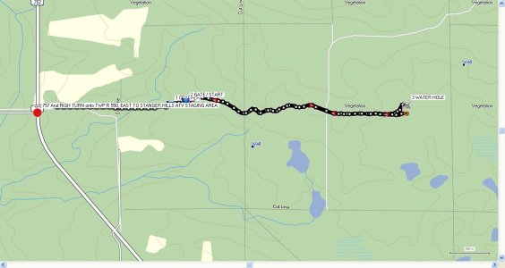
Would you have the GPS location"s for these Pix.
Bruce.
Bruce.
AB RANGER 007
Active VIP Member
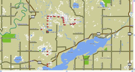
Why it it so hard to get GPS information and some GOOD JPG'S of GPS Maps for this area from the club??? The ones on their site is a joke. I have been following Reg Faulkner's Photo Shoot of the Lac St Anne Trail (Stanger Hills) on the Panoramio Photo's Site and have put to-gether some 50+ waypoints and pictures from his camera's geotaged pictures, that uses the degrees/min/ sec-sec, format.
Bruce.
Bruce.
- Admin
- #15
Why it it so hard to get GPS information and some GOOD JPG'S of GPS Maps for this area from the club??? The ones on their site is a joke. I have been following Reg Faulkner's Photo Shoot of the Lac St Anne Trail (Stanger Hills) on the Panoramio Photo's Site and have put to-gether some 50+ waypoints and pictures from his camera's geotaged pictures, that uses the degrees/min/ sec-sec, format.
Bruce.
sounds like you've just volunteered to go out and do just that for the club Bruce.
AB RANGER 007
Active VIP Member
Are you telling me that you donot ride with a GPS unit and do not have any Mapping Software. I went on a club ride in 2012 06 02 and got as far as this track and got stuck with my PR 6X6 and had to get pulled out buy 2 Quads with winches,every one had allready gone off trail to go further. STAY on the TRAILS, club rules??? and we wonder way the area gets chewd up.The riders that pulled me out called to the staging area to find out how to get back, because they were stuck.
Bruce.
Bruce.
Attachments
Last edited:
whoDEANie
Active VIP Member
I've been meaning to post a GPS track up on the website for a while. I think I'm the only one on the club board that usually carries a GPS. The only time I've ever been there is to do maintenance, so I've never ridden the trail start to finish to get a clean GPS track. I'd also like to map out some of the "satellite trails" that are available to us in the sledding off season. If we do post something up, I'd prefer that it's clean, accurate, and complete. That said, the multi-use trail is pretty short, has at least three map signs posted up on the trail, and has all the main points and intersections signed - I was planning to post up the GPS track just for "bling" on the website.
whoDEANie
Active VIP Member
Why it it so hard to get GPS information and some GOOD JPG'S of GPS Maps for this area from the club??? The ones on their site is a joke. I have been following Reg Faulkner's Photo Shoot of the Lac St Anne Trail (Stanger Hills) on the Panoramio Photo's Site and have put to-gether some 50+ waypoints and pictures from his camera's geotaged pictures, that uses the degrees/min/ sec-sec, format.
Bruce.
lol, a savy GPS user such as yourself can't do the conversion?
") OK, ok, I'll spoon feed them to you a number of different ways...
OK, ok, I'll spoon feed them to you a number of different ways...| Latitude | N 53 41.150 |
| Longitude | W 114 47.508 |
| Calculated Values - based on Degrees Lat Long to seven decimal places. | |
| Position Type | Lat Lon |
| Degrees Lat Long | 53.6858333°, -114.7918000° |
| Degrees Minutes | 53°41.15000', -114°47.50800' |
| Degrees Minutes Seconds | 53°41'09.0000", -114°47'30.4800" |
| UTM | 11U 645823mE 5950833mN |
| MGRS | 11UPV4582350833 |
| Grid North | 1.8° |
| Maidenhead | DO23OQ44XO64 |
| GEOREF | EKFJ12494115 |
| Latitude | N 53 41.197 |
| Longitude | W 114 47.779 |
| Calculated Values - based on Degrees Lat Long to seven decimal places. | |
| Position Type | Lat Lon |
| Degrees Lat Long | 53.6866167°, -114.7963167° |
| Degrees Minutes | 53°41.19700', -114°47.77900' |
| Degrees Minutes Seconds | 53°41'11.8200", -114°47'46.7400" |
| UTM | 11U 645522mE 5950910mN |
| MGRS | 11UPV4552250910 |
| Grid North | 1.8° |
| Maidenhead | DO23OQ44KS69 |
| GEOREF | EKFJ12224119 |
AB RANGER 007
Active VIP Member
GOLLY GEE !, and all the time I was just using GPSSway to do my conversions. And after doing some 50 + on this project I will move on to some where else. My BUCKET LIST is over flowing and needs to be looked into.
Incase some one is interested, attached is a PIX of the data that I have from the Reg Faulkners photos, and if you have Garmin MapSource in/ on your computer, I can send you this file direct to you, need e Mail address.
Bruce.
Incase some one is interested, attached is a PIX of the data that I have from the Reg Faulkners photos, and if you have Garmin MapSource in/ on your computer, I can send you this file direct to you, need e Mail address.
Bruce.
Attachments
Last edited:
Similar threads
- Replies
- 2
- Views
- 294
- Replies
- 27
- Views
- 2K
