
maxwell
Active VIP Member
came accross this tonight.
1. find a hill your curious about
2. click "add" --> "path"
3. select a point at the bottom and a point at the top ( google earth automatically extrapolates the line to fit the hill no need for intermediate points)
4. click "ok" to save the line
5. go to my places on the left hand tool bar
6. right click on the recently saved line and select " show elevation profile"
this gives, slope angle (in percent slope needs to be converted see chart), traveled distance and elevation change along with averages etc.
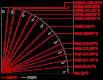
i have attached a slope angle chart aswell. percent slope does not directly relate to slope angle.
neat tool. really narrows down the hottubs stories. " you should have seen what i climbed today! it must have been 95 degrees!!" when in reality it was more like 20. LOL.


1. find a hill your curious about
2. click "add" --> "path"
3. select a point at the bottom and a point at the top ( google earth automatically extrapolates the line to fit the hill no need for intermediate points)
4. click "ok" to save the line
5. go to my places on the left hand tool bar
6. right click on the recently saved line and select " show elevation profile"
this gives, slope angle (in percent slope needs to be converted see chart), traveled distance and elevation change along with averages etc.
i have attached a slope angle chart aswell. percent slope does not directly relate to slope angle.
neat tool. really narrows down the hottubs stories. " you should have seen what i climbed today! it must have been 95 degrees!!" when in reality it was more like 20. LOL.
Attachments
Last edited:


