cool google earth feature

maxwell

Active VIP Member
Joined
Apr 25, 2007
Messages
19,914
Reaction score
42,096
Location
Sherwood Park, Alberta, Canada
came accross this tonight.


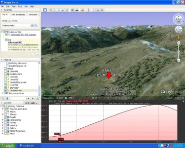
1. find a hill your curious about
2. click "add" --> "path"
3. select a point at the bottom and a point at the top ( google earth automatically extrapolates the line to fit the hill no need for intermediate points)
4. click "ok" to save the line
5. go to my places on the left hand tool bar
6. right click on the recently saved line and select " show elevation profile"

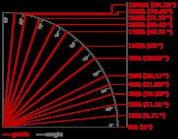
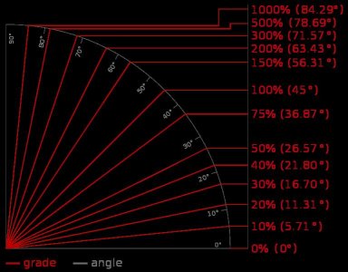
this gives, slope angle (in percent slope needs to be converted see chart), traveled distance and elevation change along with averages etc.

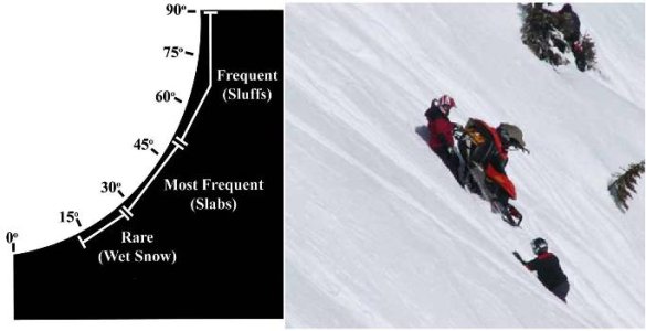
i have attached a slope angle chart aswell. percent slope does not directly relate to slope angle.

neat tool. really narrows down the hottubs stories. " you should have seen what i climbed today! it must have been 95 degrees!!" when in reality it was more like 20. LOL.
google earth slope.jpg

GRADE-DEGREES.JPG
 

Attachments

  • 767px-Grades_degrees.svg.jpg
    767px-Grades_degrees.svg.jpg
    21.2 KB · Views: 429
Last edited:

ferniesnow

I'm doo-ing it!
Joined
Dec 2, 2008
Messages
108,853
Reaction score
83,172
Location
beautiful, downtown Salmon Arm, BC
Yes, those features are cool! With the new trail through the Rolling Hills that was what I ultimately used to see if the slope/distance would be compatible with the SnowCat's ability.

Your use carries that one step further; good for you young guys and your use of technology. :xmas2004_15:
 

pipes

Active VIP Member
Joined
Dec 23, 2008
Messages
25,949
Reaction score
36,414
Location
Bonnyville Alberta
I don't know Maxwell. I tried this feature on Mount Robson and I don't think so. Or may be I'm doing it wrong.
 

maxwell

Active VIP Member
Joined
Apr 25, 2007
Messages
19,914
Reaction score
42,096
Location
Sherwood Park, Alberta, Canada
just checked it most of its around 40-45 degrees. seems legit when you look at it from a side perspective. keep in mind the chart veiw is going to look shallow because its a huge elevation change over a long distance ( 5 +km vertical )
 

Summit X

Active VIP Member
Joined
Nov 7, 2006
Messages
845
Reaction score
862
Location
Calgary
pretty neat tool. the only catch is the accuracy of the data used by google earth...

google earth takes one elevation point every 10m in the USA and interpolates the area inbetween. In Canada, they usually only have a point every 100m and at best it is 30m, so there is a lot of interpolation. but you get what you pay for!
 

pfi572

Active VIP Member
Joined
Mar 10, 2010
Messages
6,064
Reaction score
15,262
Location
Grande Prairie
Another thing is keep your hand held GPS on and save the track. You can then put the track on Google to see what and were you have sledded.
If you have have topo canada you save it to it and then view in Google earth.
See all your tracks and elevations at the push of a button.
 

takethebounce

Active VIP Member
Joined
Dec 10, 2008
Messages
5,193
Reaction score
8,750
Location
calgary
Another thing is keep your hand held GPS on and save the track. You can then put the track on Google to see what and were you have sledded.
If you have have topo canada you save it to it and then view in Google earth.
See all your tracks and elevations at the push of a button.

I was going to add the Backroad Maps GPS instead of the Topo Canada, any idea if you can do something simular with that package?

Nice find Maxwell.
 

clarkydubs

Active VIP Member
Joined
Jan 4, 2011
Messages
151
Reaction score
309
Location
nelson
i use the mammut app on my phone, has a clinometer??? sure helps serve the humble pie up to those guys climbing "vert"....
 
Top Bottom