gps software

imdoo'n

Active VIP Member
Joined
Jan 15, 2008
Messages
57,275
Reaction score
50,367
Location
alberta
i'm using the garmin topo not bad, but lacks alot of the trails we ride on, ibycus looks a little better, bushmaps look ok, not sure about bc content.

from there web site, backroads looks the best so far. anyone have a chance to compare them together.
 
Last edited:

nast70

Active VIP Member
Joined
Jan 14, 2010
Messages
825
Reaction score
2,049
Location
edmonton
Haven't really compared them but run Backroads on my Garmin. Good maps, lots of trail systems show up, but for me the big selling point is in the extras menu, boat launches, winter staging areas, lake and fishing info, basically everything in the backroads map book on the gps. we bought it as a package at the sportsman show a few years back. At that time they were requesting tracks of trail systems for updates. i've never seen one, but have never looked very hard either.

Here's the link for the backroads website:
 
Last edited:

imdoo'n

Active VIP Member
Joined
Jan 15, 2008
Messages
57,275
Reaction score
50,367
Location
alberta
which model gps are you using, the gps city web site says the backroads will work on the rhino but not all the features, rino 530hcx, the rino 650 is only slightly better.
 

imdoo'n

Active VIP Member
Joined
Jan 15, 2008
Messages
57,275
Reaction score
50,367
Location
alberta
should change name to marval mtn. as in would be marvelous to find the sucker.
 

camoJoe

Active VIP Member
Joined
Jun 20, 2013
Messages
480
Reaction score
420
Location
Alberta bound
Can compare Topo Canada to Backroad maps, topo Canada is bare bones compared to backroad maps running version 3 of Backroad maps AB-BC at moment on my Garmin 60Csx (now obsolete , go figure ) very happy with backroad maps, does not show all cut lines, do seem to be popping up with updates. does show the odd trails people have uploaded to backroad maps.
 

AB RANGER 007

Active VIP Member
Joined
Aug 1, 2008
Messages
451
Reaction score
201
Location
Vilna, AB,
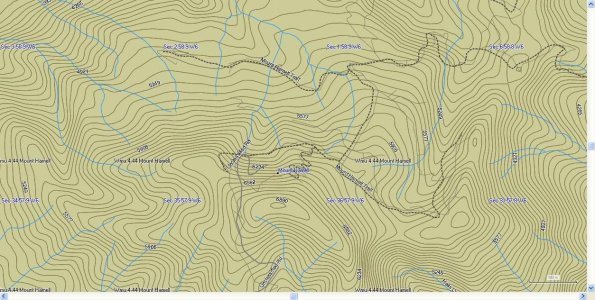
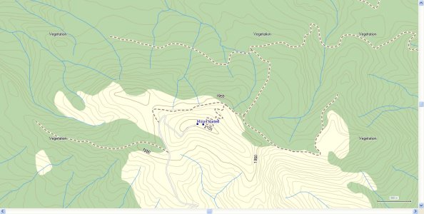
camoJoe, I have the Backroad GPS Maps AB/BC v2.1 and there is a error in the position of Mt Hammel, North of Grande Cashe AB. as well as others, I will attemp to attache JPG'S of the Positon on the Backroad Gps Maps and the ibycus Canada Topo V2.1 for your comparison on the B GPS M v3 to see if they made the correction on the info that I sent them. Thank You. Bruce. Mt Hammel.jpg Mt Hammel ibycus 2.1.JPG
 

arff

Active VIP Member
Joined
Apr 21, 2009
Messages
139,387
Reaction score
55,122
Location
Leduc
I am using bushmaps
 

arff

Active VIP Member
Joined
Apr 21, 2009
Messages
139,387
Reaction score
55,122
Location
Leduc
Shows lease roads water crossing,lakes etc. Works for me
 

arff

Active VIP Member
Joined
Apr 21, 2009
Messages
139,387
Reaction score
55,122
Location
Leduc
Which Marble Mountain are you talking about? Is it the one in Alberta?


Oh yes.. A magical place. We did go to the top of it once a few years ago.
 

imdoo'n

Active VIP Member
Joined
Jan 15, 2008
Messages
57,275
Reaction score
50,367
Location
alberta
atv and also sled .

only now the west side is devoid of trees.
 

arff

Active VIP Member
Joined
Apr 21, 2009
Messages
139,387
Reaction score
55,122
Location
Leduc
Imdooin a friend of mine and myself made the journey.
 

imdoo'n

Active VIP Member
Joined
Jan 15, 2008
Messages
57,275
Reaction score
50,367
Location
alberta
We rode from rig street, had a great ride
 

imdoo'n

Active VIP Member
Joined
Jan 15, 2008
Messages
57,275
Reaction score
50,367
Location
alberta
Yes real easy to lose your pants, then you become famous, yer on the internet with yer azz for all to see. Is a nice ride, but be careful on the climb up the mtn. Can be dangerous.
 

imdoo'n

Active VIP Member
Joined
Jan 15, 2008
Messages
57,275
Reaction score
50,367
Location
alberta
So far like the looks of backroad maps,
 
Top Bottom