- Staff
- #1
- Joined
- Oct 21, 2006
- Messages
- 48,004
- Reaction score
- 32,148
- Location
- Edmonton/Sherwood Park
- Website
- www.bumpertobumper.ca
May 08, 2022
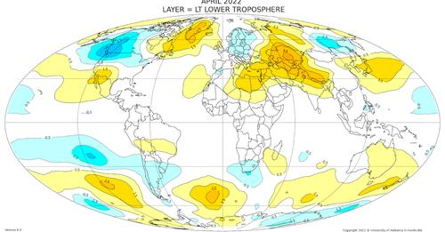
The Coldest April in the Satellite Record over the Pacific Northwest
You knew it was colder than normal over the Pacific Northwest during April.
But the cold was not limited to the surface. Let me show you the chilly story in a very new way: using satellite temperature soundings in the vertical.
By measuring infrared or microwave radiation emitted by the atmosphere, satellites can measure how temperature varies in the vertical. Not unlike how infrared ear thermometers work by sensing the radiation emitted by your eardrum!
Below are the differences from normal of the April temperatures in the lowest 10 km (lowest 33, 000 ft) of the atmosphere, with normal being the average for 1991 through 2020.
Blues are colder than normal and yellow/oranges are warmer than normal. This map and associated data were provided by Professor John Christy of the University of Alabama in Huntsville, who is a well-known expert in such work.
The coldest temperature anomalies (differences from normal) over the entire planet are found the Pacific Northwest, with the deviations from normal exceeding 2.5 C! (4.5F). A blow-up for the Northwest is shown below.


But there is another point you need to consider: there are all kinds of temperature anomalies all over the planet, including a major warm anomaly over Kazakstan.
Differences from normal, both warm and cold, are....well...normal. These patterns occur naturally as troughs (low pressure) and ridges (high pressure) move and develop.
But there is more! This cold anomaly over the Northwest is the COLDEST ever observed since the beginning of satellite temperatures collection (1979). This is shown in the plot below.

You will also notice something that else that is very important...there is little long-term trend for April temperatures over our region. This is consistent with the observation that our snowpack has shown little long-term trend over the region.
May is Not Any Better
And now the depressing part. May is also turning out to be cool....and wet.
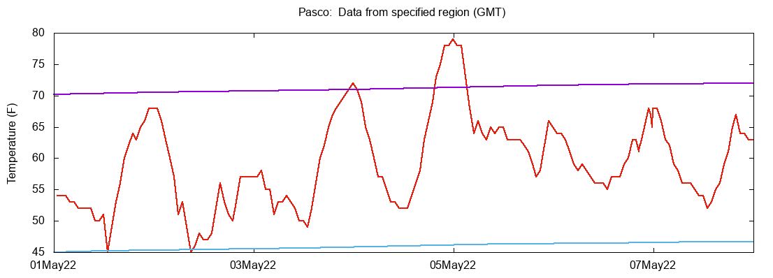
At Sea Tac Airport, every day but one in May has been below normal, with highs on many days around TEN DEGREES below normal.

Slightly better in eastern WA, with Pasco's temperature reaching normal highs twice this month.
The silver lining in all of this is that with lots of precipitation and cold temperatures, the snowpack has surged to well above normal for the entire state (see below). Late ski season. Delays wildfire season. Lots of water for the summer.

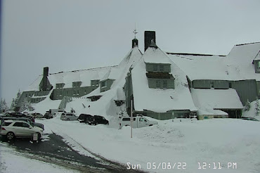
During the last 24 hour, NINETEEN INCHES of snow has fallen at Timberline Lodge on the slopes of Mt. Hood. Amazing.
And now the REALLY depressing news for lovers of warmth. The latest European Center ensemble forecast for the next ten days predicts MUCH cooler than normal temperatures over the region.