What Gps is best for sledding?

Rbrduk

Active VIP Member
Joined
Mar 27, 2012
Messages
10,855
Reaction score
8,338
Location
Dickson,AB
You can get some lithium ion rechargeable batteries out of china, pretty expensive, 50 dollars for two AA's. They last 12hrs and have consistent power for all 12hrs in cold weather. Of coarse if you want satellite with any of the handheld gps you are going to have to purchase a subscription for around 30 dollars each year, garmin is just a bit more money than magelllans, the screens are really small with slow download speeds. I just use a tablet now with a built in gps with two apps which are Memory maps and google earth, battery life is incredible and clarity is unbelievable, nautical charts are also available. For that a laptop using globalsat bu-353-s4 usb gps connection which is windows 10 compliant. Pilots the tablet works just fine.

Question?
What do you mean by needing a subscription for satellites on a handheld gps unit.?
I'm a surveyor and been running gps for years. Be it for work ( base and rover ) or personal hand held units and never had to purchase a subscription on any of it.
 

sweld

Active VIP Member
Joined
Dec 20, 2009
Messages
1,363
Reaction score
1,591
Location
Redwater
Sorry but you don't need a subscription for a gps. In reach. Spot or a sat phone yes


Sent from my iPhone using Tapatalk
 

X-it

Active VIP Member
Joined
Jan 8, 2007
Messages
7,320
Reaction score
16,412
Location
Prince George
If you are a tree rider and want to sneak through the trees and ride untracked country, you will want a subscription. Most people will not need it though.
 

sweld

Active VIP Member
Joined
Dec 20, 2009
Messages
1,363
Reaction score
1,591
Location
Redwater
If you are a tree rider and want to sneak through the trees and ride untracked country, you will want a subscription. Most people will not need it though.

Don't have a subscription for my rino and it tracks me just fine.


Sent from my iPhone using Tapatalk
 

X-it

Active VIP Member
Joined
Jan 8, 2007
Messages
7,320
Reaction score
16,412
Location
Prince George
I will have to add Birdseye is not as clear as they want you to think it is. Some areas meaning.. very few are highest clearity, at least where i have gone. Once you download an area it is yours for as long as you want to keep, meaning a yearly subscription is no longer needed to see satellite few, poor quality satellite view that is.
 

X-it

Active VIP Member
Joined
Jan 8, 2007
Messages
7,320
Reaction score
16,412
Location
Prince George
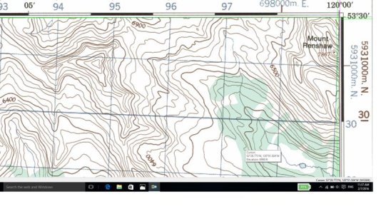
If you ever get a chance try memory maps and see what their topo contour lines are like. It can be downloaded on a phone with gps. Awkward to use but once you figure it out it is stunning. Here is a actual shot from memory maps. More Zoom features can be used as well. Even worked inside a westjet airline, never had a gps do this before
 
Last edited:

X-it

Active VIP Member
Joined
Jan 8, 2007
Messages
7,320
Reaction score
16,412
Location
Prince George
renshaw.jpg
 

X-it

Active VIP Member
Joined
Jan 8, 2007
Messages
7,320
Reaction score
16,412
Location
Prince George
One other thing i would like to comment on but know nothing about, sweld said they had spot. Can you emagine your phone doing it all. Memory maps has an extensive licensing agreement here is one of them. I have not use it though!!!!
 
Top Bottom